El Oued
|
الوادي El Oued |
||
|---|---|---|
|
|
||
| Coordinates | 33 ° 22 '6 " N , 6 ° 52' 3" E | |
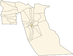
 Location in the province of El Oued |
||
| Basic data | ||
| Country | Algeria | |
| El Oued | ||
| ISO 3166-2 | DZ-39 | |
| height | 74 m | |
| surface | 77 km² | |
| Residents | 134,699 (2008) | |
| density | 1,749.3 Ew. / km² | |
|
El Oued (1985)
|
||
El Oued ( Arabic الوادي, DMG Al-Wādī ) is a municipality with around 135,000 inhabitants and is the capital of the province of El Oued in eastern Algeria . Alternatively, the term Oued Souf , after the surrounding Souf region , is also used in the vernacular .
Geographical location
As an urban settlement, El Oued is around 74 m above sea level, around 75 km west of the border with Tunisia and 510 km southeast of Algiers . The municipality is located around 90 km southeast of the Schott Melghir in the center of a low-lying oasis region in the north of the sandy desert of the Eastern Great Erg . The closest major city to the west is Touggourt, 75 km away .
In addition to the core town of El Oued, the municipality also consists of the villages of Keraima, Legtouta, Mahda, Mih Bahi Sud and Oum Sahaouine .
traffic
In terms of traffic, El Oued is accessed by the national roads N16 and N48, which branch off from national road 3, which runs 70 km further to the west . The N16 reaches the outskirts of the city in the southwest from the direction of Touggourt and continues, partly close to the border with Tunisia, further northeast to Annaba on the Mediterranean. The N48 reaches the city from the north and provides the shortest connection to Biskra and in the direction of Algiers . It leaves the city to the northeast on the same route as the N16, then branches off to the east and leads to a border crossing in front of the Tunisian city of Nefta . The El Oued airport located in the territory of the northern adjacent municipality Guemar at the N48 and is km to reach from the city center in the 17th
Web links
Individual evidence
- ↑ Office National des Statistiques Algérie: Population selon la commune de résidence (1998-2008)
- ↑ Altitude information El Oued at Geonames
- ↑ Measure distance with google maps
- ↑ Journal officiel de la République Algérienne, December 19, 1984: Décret n ° 84-365, fixant la composition, la consistance et les limites territoriale des communes, page 1564
- ↑ Guemar Airport at fallingrain.com
- ↑ Guemar Airport at Geonames

