
Ziepniekkalns: Difference between revisions
No edit summary Tag: Reverted |
Estopedist1 (talk | contribs) →top: short desc (+ format) |
||
| (7 intermediate revisions by 5 users not shown) | |||
| Line 1: | Line 1: | ||
{{Short description|Neighborhood of Riga, Latvia}} |
|||
{{Expand Latvian|Ziepniekkalns|topic=geo|date=March 2011}} |
{{Expand Latvian|Ziepniekkalns|topic=geo|date=March 2011}} |
||
{{Infobox settlement |
{{Infobox settlement |
||
| name |
| name = Ziepniekkalns |
||
| settlement_type |
| settlement_type = Neighborhood of Riga |
||
| image_skyline |
| image_skyline = Ziepniekkalns, Riga, Latvia 1.jpg |
||
| image_size |
| image_size = 220px |
||
| image_caption |
| image_caption = Typical inner yard in Ziepniekkalns (2022) |
||
| image_flag |
| image_flag = |
||
| image_seal |
| image_seal = |
||
| image_map |
| image_map = Ziepniekkalns karte.png |
||
| map_caption |
| map_caption = Location in Riga |
||
| subdivision_type |
| subdivision_type = Country |
||
| subdivision_name |
| subdivision_name = [[Latvia]] |
||
| subdivision_type1 |
| subdivision_type1 = City |
||
| subdivision_name1 |
| subdivision_name1 = [[Riga]] |
||
| subdivision_type2 |
| subdivision_type2 = District |
||
| subdivision_name2 |
| subdivision_name2 = [[Zemgale Suburb, Riga|Zemgale Suburb]] |
||
| leader_title |
| leader_title = |
||
| leader_name |
| leader_name = |
||
| established_title |
| established_title = |
||
| established_date |
| established_date = |
||
| area_total_km2 |
| area_total_km2 = 10.917 |
||
| area_water_km2 |
| area_water_km2 = |
||
| population_as_of |
| population_as_of = 2018 |
||
| population_note |
| population_note = |
||
| population_total |
| population_total = 33016 |
||
| population_metro |
| population_metro = |
||
| population_density_km2 |
| population_density_km2 = auto |
||
| timezone |
| timezone = [[Eastern European Time|EET]] |
||
| utc_offset |
| utc_offset = +2 |
||
| timezone_DST |
| timezone_DST = [[Eastern European Summer Time|EEST]] |
||
| utc_offset_DST |
| utc_offset_DST = +3 |
||
| coordinates |
| coordinates = |
||
| elevation_m |
| elevation_m = |
||
| postal_code |
| postal_code = LV-1058 |
||
| area_code |
| area_code = |
||
| blank_name |
| blank_name = |
||
| blank_info |
| blank_info = |
||
| website |
| website = [https://apkaimes.lv/ziepniekkalns/ apkaimes.lv] |
||
| footnotes |
| footnotes = |
||
| official_name |
| official_name = |
||
}} |
}} |
||
'''Ziepniekkalns''' is a neighborhood of [[Riga]], [[Latvia]]. It is located in the [[Pārdaugava]] section of [[Riga]] close to the city's southern border. Ziepniekkalns is the latest out of all Riga's neighborhoods.<ref>{{cite web|url=http://www.apkaimes.lv/sakums/ziepniekkalns/history/|title=Apkaimes vēsturiskais apraksts|publisher= apkaimes.lv|date=2013|access-date=May 7, 2015}}</ref> |
'''Ziepniekkalns''' is a neighborhood of [[Riga]], [[Latvia]]. It is located in the [[Pārdaugava]] section of [[Riga]] close to the city's southern border. Ziepniekkalns is the latest out of all Riga's neighborhoods.<ref>{{cite web|url=http://www.apkaimes.lv/sakums/ziepniekkalns/history/|title=Apkaimes vēsturiskais apraksts|publisher= apkaimes.lv|date=2013|access-date=May 7, 2015}}</ref> |
||
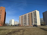
It was built in the late 1980s and early 1990s and mostly consists of Soviet-built 10 story apartment buildings. |
It was built in the late 1980s and early 1990s and mostly consists of Soviet-built 10 story apartment buildings. However, there are still many older buildings in Ziepniekkalns constructed in the early 1960s. There is a major contrast between older 3 story buildings and newer 10 story ones. |
||
In the mid-1990s, route [[Rīgas Satiksme|19]] [[trolleybus]] was extended to the heart of new Ziepniekkalns and now |
In the mid-1990s, route [[Rīgas Satiksme|19]] [[trolleybus]] was extended to the heart of new Ziepniekkalns and now final stop is at the Mego [[supermarket]]. The trolleybus route [[Rīgas Satiksme|4]] runs through the city center to [[Jugla, Riga|Jugla]].<ref>{{cite web|url=http://www.rdpad.lv/wp-content/uploads/2014/12/4_apkaime_Ziepniekkalns_atskaite.pdf|title= Iedzīvotāju aptauja par dzīvi apkaimē 4.Ziepniekkalns|publisher= Rīgas domes pilsētas attīstības departaments|date=2013|access-date=May 7, 2015}}</ref> |
||
== Gallery == |
|||
<gallery widths="200" heights="160"> |
<gallery widths="200" heights="160"> |
||
| ⚫ | |||
File:Vendors in Ziepniekkalns.JPG|Street market in Ziepniekkalns |
File:Vendors in Ziepniekkalns.JPG|Street market in Ziepniekkalns |
||
File:Dzintars Latvia.JPG|Office of perfumery and cosmetics factory Dzintars |
File:Dzintars Latvia.JPG|Office of perfumery and cosmetics factory Dzintars |
||
File:Dub ebelmuizhas.jpg|Ancient Oak Tree of Ēbelmuiža |
File:Dub ebelmuizhas.jpg|Ancient Oak Tree of Ēbelmuiža |
||
File:Ziepniekkalna.JPG|Ziepniekkalns forest |
File:Ziepniekkalna.JPG|Ziepniekkalns forest |
||
File:Ozolciema iela, Ziepniekkalns, Riga, Latvia.jpg|Longest apartment building in Latvia, Ozolciema street 18. |
|||
| ⚫ | |||
File:Ozolciema iela, Ziepniekkalns, Riga, Latvia 2.jpg |
|||
File:Ziepniekkalns, Riga, Latvia 2.jpg |
|||
</gallery> |
</gallery> |
||
| Line 61: | Line 66: | ||
{{Riga's neighbourhoods}} |
{{Riga's neighbourhoods}} |
||
{{Authority control}} |
|||
{{ |
{{Coord|56.95|N|24|E|source:kolossus-ruwiki|display=title}} |
||
[[Category:Neighbourhoods in Riga]] |
[[Category:Neighbourhoods in Riga]] |
||
Latest revision as of 13:09, 1 April 2024
You can help expand this article with text translated from the corresponding article in Latvian. (March 2011) Click [show] for important translation instructions.
|
Ziepniekkalns | |
|---|---|
Neighborhood of Riga | |
 Typical inner yard in Ziepniekkalns (2022) | |
 Location in Riga | |
| Country | Latvia |
| City | Riga |
| District | Zemgale Suburb |
| Area | |
| • Total | 10.917 km2 (4.215 sq mi) |
| Population (2018) | |
| • Total | 33,016 |
| • Density | 3,000/km2 (7,800/sq mi) |
| Time zone | UTC+2 (EET) |
| • Summer (DST) | UTC+3 (EEST) |
| Website | apkaimes.lv |
Ziepniekkalns is a neighborhood of Riga, Latvia. It is located in the Pārdaugava section of Riga close to the city's southern border. Ziepniekkalns is the latest out of all Riga's neighborhoods.[1] It was built in the late 1980s and early 1990s and mostly consists of Soviet-built 10 story apartment buildings. However, there are still many older buildings in Ziepniekkalns constructed in the early 1960s. There is a major contrast between older 3 story buildings and newer 10 story ones. In the mid-1990s, route 19 trolleybus was extended to the heart of new Ziepniekkalns and now final stop is at the Mego supermarket. The trolleybus route 4 runs through the city center to Jugla.[2]
Gallery[edit]
-
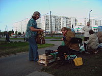 Street market in Ziepniekkalns
 -
 Office of perfumery and cosmetics factory Dzintars
 -
 Ancient Oak Tree of Ēbelmuiža
 -
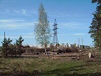 Ziepniekkalns forest
 -
 Longest apartment building in Latvia, Ozolciema street 18.
 -
 Typical inner yard in Ziepniekkalns
 -
-


References[edit]
- ^ "Apkaimes vēsturiskais apraksts". apkaimes.lv. 2013. Retrieved May 7, 2015.
- ^ "Iedzīvotāju aptauja par dzīvi apkaimē 4.Ziepniekkalns" (PDF). Rīgas domes pilsētas attīstības departaments. 2013. Retrieved May 7, 2015.
Sources[edit]
- Jērāns, Pēteris (1988). Latvijas padomju enciklopēdija: Rīga. Rīga: Valērija Belokoņa izdevniecība. p. 733. ISBN 9984-9482-2-6.
| Authority control databases: National |
|---|
56°57′N 24°00′E / 56.95°N 24°E
This Riga location article is a stub. You can help Wikipedia by expanding it. |