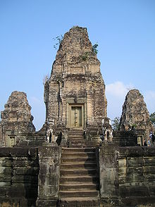
Eastern Baray
The eastern Baray is a former water reservoir of the Khmer Empire and part of the Angkor World Heritage Site ( Siem Reap Province , Cambodia ). In this huge water basin, which was built by Yasovarman I (889–910), Rajendravarman II (944–968) had a temple, the Eastern Mebon, built on an artificial island . The Baray has now dried up and the former island temple is now in the middle of the rice fields.
history
When Yasovarman I became king of the Khmer Empire in 889, he gave the order to build the 7.5 km × 1.83 km eastern Baray and a new capital. The reservoir that was supposed to secure the water supply for the new capital Yasodharapura and agriculture and also regulate the Roluos River was called Yasodharatataka , the "water basin of Yasodhara". Zhou Daguan , who lived in Angkor from 1296 to 1297 as a member of a Chinese delegation, called the Baray (in his writing about life in Angkor in the 13th century) "Eastern Sea".
Eastern Baray
The Baray was precisely oriented from west to east. At its corners, steles with inscriptions in Sanskrit were placed, which placed the eastern Baray under the protection of Ganga , the sacred personification of the Ganges . The Roluos River fed the reservoir through a canal from the northeast. A high earth dam, which was clad with laterite , formed the reservoir. At a water level of 4 m, the basin contained 55 million cubic meters of water. Other estimates assume a water level of 3 m and 40 million cubic meters.
In the first half of the 11th century, the function of the leaky eastern Baray was replaced by a new water reservoir, the western Baray . Today the silted up area of the eastern Baray is used for rice cultivation.
Eastern Mebon
There are different opinions on the question of whether Yasovarman I or Rajendravarman II had the artificial island built in Baray on which the Eastern Mebon stands. In one of the six Bat Chum inscriptions it is said that Rajendravarman II (944–968) had given his minister and architect Kavindrarimathana the instruction to create an artificial island temple in Yasodharatataka.
The artificial island, built from laterite blocks, has a square base area of 120 m on a side. The island block is not exactly in the center of the reservoir, but a little south of it. Rajendravarman II (944–968) commissioned his minister and architect (the only builder of the Khmer Empire known by name) to build the island temple. The sanctuary was consecrated (according to the so-called Mebon inscription) in 952. The temple is built in the Pre Rup style (944-968) (the name given to the style was the 500 m south, nine years later (961) inaugurated state temple of Rajendravarman II.). The numerous lintels with the very plastic reliefs are among the most beautiful of the Khmer Empire.
The Shiva temple, laid out on four levels, is crowned by five large brick towers in a quincunx position, with the middle and largest Prasat on the fourth level and the four corner towers of the quincunx on the third level. On the second level there is the inner (1st) surrounding wall with four (not cross-shaped) gates and within the wall five libraries and eight smaller towers. On the first level (ie on the island platform) are the outer (2nd) enclosing wall with four large (inwardly moved) cross-shaped gopuras and numerous gallery-like buildings within the wall. A total of eight stone elephants, approx. 2 m tall, stand in the corners of the first and second levels. All axially arranged stairs were flanked by a pair of lions. In the middle of each side of the island was a dock for the boats. Although the Baray is dry today, only a part of the pedestal-like island can be seen, as large embankments cover the lower part.
Web links
- East Mebon. In: Web presence Authority for the Protection and Management of Angkor and the Region of Siem Reap (APSARA). Retrieved March 3, 2012 .
Individual evidence
- ^ A b Maurice Glaize: Les Monuments du groupe d'Angkor . 4th edition. Adrien-Maisonneuve, Paris 1993, ISBN 2-7200-1091-X , p. 161 (French, 285 p., Translation into English by Nils Tremmel [PDF; 8.0 MB ; accessed on August 11, 2011] First edition: Portail, Saigon 1944).
- ↑ Freemann Michael, Jacques Claude: The old Angkor. 1st German edition. River Books, Bangkok 2006 ISBN 974-9863-35-6 , p. 161.
- ↑ a b c Dawn F. Rooney: Angkor . Cambodia's wondrous Khmer Temples. 6th edition. Odyssey Books & Guides, Hong Kong 2011, ISBN 978-962-217-802-1 , pp. 295 .
- ↑ Michael Freeman, Claude Jacques: Ancient Angkor . 2nd Edition. River Books, Bangkok 2003, ISBN 974-8225-27-5 , pp. 161 (English).
- ↑ Jochen Mertens: The Sanskrit inscriptions from Bat Chum. Books on Demand, Norderstedt 2005, ISBN 3-8334-2497-4 , p. 36 and p. 50.
- ↑ Jochen Mertens: The Sanskrit inscriptions from Bat Chum. Books on Demand, Norderstedt 2005, ISBN 3-8334-2497-4 , p. 30.
- ↑ Michael Freeman, Claude Jacques: Ancient Angkor . 2nd Edition. River Books, Bangkok 2003, ISBN 974-8225-27-5 , pp. 161, 162 (English).
Coordinates: 13 ° 26 ′ 51 ″ N , 103 ° 55 ′ 19 ″ E

