Baray


Baray ( Khmer language ) is an extensive, strictly rectangular water reservoir created in Angkor times in today's Cambodia and the heart of the so-called hydraulic city, at the same time a symbol of cosmological ideas.
The heart of the hydraulic city
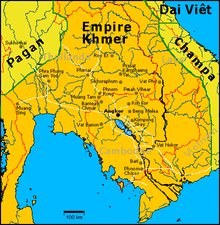
The Khmer empire existed from the 9th to the 16th century and extended over Angkor near today's Siem Reap and some neighboring areas.
In 2007, an international group of scientists was able to confirm the thesis that Angkor was a huge "hydraulic city", ie a city that worked on the basis of a complex irrigation and drainage system. Beyond the city walls of Angkor Thom , a conglomerate of agricultural and settled areas had spread over at least 1000 km², an urban agglomeration that was about ten times larger than the largest centers in the ancient world; Larger settlements were not known until the industrial age. For comparison: Berlin today covers almost 900 km².
From an agricultural point of view, the study refuted prevailing opinions: It showed that the irrigation system was indeed capable of significantly intensifying rice cultivation. Every source of water was ruthlessly exploited; the baray served as reservoirs; numerous outgoing distribution channels supplied the region. Problems have increased over the centuries: leaching of the soil and erosion , overpopulation , vulnerability to natural disasters and wars . The decline of the Angkorreich could be linked to these problems.
Symbol of cosmological ideas
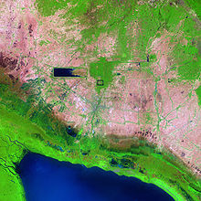
The largest baray of the central Angkor area are, in chronological order, the Baray of Lolei , the Eastern , Western and Northern Baray , also called the Baray of Preah Khan . The Western Baray (originally 8 × 2.2 km in size and up to 5 m deep) still has a significant water surface today.
The real challenge was the geological situation: the low -lying plain sloping slightly towards the Tonle Sap Lake . A Baray was a dammed-up, not excavated reservoir with massive earth walls - in contrast to the smaller Srah Srang . The water level was therefore above the natural level. The respective river was tapped further up, and the inlet channel was given a lower gradient than the surrounding area; consequently the dams of the inlet channel towards Baray became higher and higher. The water reservoir itself lay across the natural slope so that the lower dams did not have to be too high.
Although the natural terrain of the central Angkor area does not drop directly towards the south, but rather towards SSW, the sides of the above-mentioned systems look uncompromisingly in the main directions. This is a clear indication that a baray, just like a Khmer temple, represents cosmological ideas. The water surface symbolizes the ocean, a temple island in the middle the mountain Meru , on which the gods live. The orientation in the main cardinal points conjures harmony with earth and sky.
literature
- Michael Freeman, Claude Jacques: Ancient Angkor . River Books, Bangkok 1999, ISBN 974-8225-27-5 .
- Johann Reinhart Zieger: Angkor and the Khmer temples in Cambodia . Silkworm Books, Chiang Mai 2006, ISBN 974-9575-60-1 .
Web links
- Markus Becker: Angkor: Researchers discover the ruins of a huge jungle metropolis. In: Spiegel Online . August 13, 2007, accessed January 8, 2017 .