Angkor Thom
Angkor Thom ( Khmer : អង្គរធំ , "Big City") was established as the new capital of the Angkor Empire from the end of the 12th and beginning of the 13th century at the behest of King Jayavarman VII . The preserved buildings and ruins can be found today about 7 km north of the city of Siem Reap ( Cambodia ) and about 1 km north of the famous Angkor Wat temple .
history
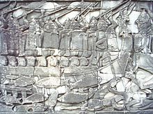
In 1177 the Cham won a naval battle on the Tonle Sap Lake against the Khmer , conquered their then capital Jayenfranagari and killed King Tribhuvanādityavarman. In four years of fighting a young general and prince succeeded in defeating the invaders; in 1181 he ascended the throne as Jayavarman VII, and during his thirty years' reign he proved to be one of the most important kings of Angkor. Since the king, unlike his Hindu predecessors, was a Mahayana - Buddhist , a large number of Buddhist temples, monasteries and universities were built on his behalf - inside and outside the city walls of his new "great capital", Angkor Thom.
His perhaps direct successor Indravarman II (reign around 1220–1243) continued the building program; Jayavarman VIII (around 1243-1295) was responsible for the destruction of numerous Buddhist sculptures and restored some important Hindu temples; in Srindravarman (around 1295–1307) we meet the first Theravada Buddhist among the Angkor kings. Now the local building history can no longer be traced, because in the emerging Theravada Buddhism almost only wooden buildings were built.
Numerous armed conflicts with Siam , but also emerging problems with the water supply and soil fertility, led to the decline of the Angkor Reich by the end of the 16th century. The so-called discovery of Angkor in the second half of the 19th century (a nonsensical term because the Khmer had never forgotten the temples and other European visitors had long since described them) is closely linked to the name of Henri Mouhot , and the history of the renovation in particular to that École française d'Extrême-Orient . Since 1992, the Angkorgebiet and thus Angkor Thom to include from the UNESCO recognized World Heritage Site .
investment
Angkor Thom occupies the northern part of the first Angkor capital, Yasodharapura. This made the new capital smaller than its historical predecessor; but it was larger than all cities of the European Middle Ages.
The square complex has a side length of about 3 km, the four sides point in the main directions. The surrounding moat is 100 m wide. The laterite city wall is about 8 m high and has a generous fill of earth on the inside. The city is opened up and divided into quarters by a street cross. The four ends of the street lead into city gates made of sandstone , a fifth, the Siegestor, is located 500 m north of the east gate at the end of another street, the so-called Siegesallee. This leads away from the former royal palace near the Phimeanakas temple pyramid, while the road cross starts from the Bayon.
Jayavarman VII incorporated important structures in the historic capital into his new capital. The royal palace with the temple pyramid Phimeanakas was in the north-western quarter . He and his successors supplemented this ensemble with the Terrace of the Elephants and the Terrace of the Leper King, the Great Square , the Prasat Suor Prat tower series and the aforementioned Victory Avenue . The older, overwhelmingly large Temple Mount Baphuon and two hall-like buildings, the northern and southern Khleang, were also integrated into the overall plan. In the geometric center of Angkor Thom, cut out and framed by the streets, the state temple Bayon with its forest of face towers was created. Apart from the temples and terraces, all the buildings in the city were made of wood (including the royal palace) and have now disappeared.
List of all stone buildings within the city walls (dating from Zieger):
- Baphuon , huge Temple Mount, mid-11th century
- Bayon , state temple with numerous face towers, early 13th century.
- Khleang , two hall-like buildings, early 11th century
- "Small temple", ruin, mid-10th century.
- Mangalartha , the latest stone building in Angkor, late 13th century.
- “Monument 486”, three towers, late period
- Phimeanakas , steep temple pyramid, late 10th, early 11th century
- Prasat Suor Prat , twelve towers, late 12th, early 13th century
- Preah Palilay , an atmospheric Buddhist temple, first half of the 12th century or 13th to 14th century.
- Preah Pithu , a group of temple ruins, 12th to 13th centuries
- Tep Pranam , a terrace with a later Buddha statue
- Terrace of the Elephants , late 12th century
- Terrace of the Leper King , late 12th century
- Vihear Prampil Loveng , a terrace on which the restored central Buddha statue from the Bayon now stands
Each district was divided into 6 by 6 fields by a network of paths. Canals were also used for traffic - but also for water supply and sewage disposal. The well-preserved sewage systems in the south-west corner of the city, at its lowest point, and the not far away Baray (reservoirs) still testify to the water management skills of the Khmer .
Like a temple mountain on a smaller scale , Angkor Thom on a larger scale is a model of the world according to Hindu- Jain- Buddhist ideas: harmoniously aligned in the cardinal points, surrounded by water and with the mountain of the gods Meru in the center, which is symbolized by the bayon. At his feet lies the city as Jambudvipa . The Buddhist cosmology is reflected in the wall ring and moat, because according to it, the world is enclosed by a rock wall, beyond which the primordial ocean lies.
Dams, gates and corner towers
The city can be reached from the surrounding area via five dams through five gate towers. The dams are about 15 m wide and covered with sandstone; they cross the moats. 54 deities each serve as side balustrades , devas on the left and asuras on the right , carrying a naga , a serpent creature. The devas of the south gate correspond to the asuras of the north gate and vice versa. The same applies to the west and east gates. This dynamic between gods and demons with the bayon as the fulcrum and symbol for Mount Meru and the Nagabalustrade as Vasuki corresponds to the creation myth of the whisking of the milk ocean .
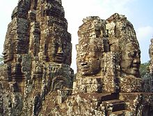
Like the balustrades, the gopuram , the gate towers, are made of sandstone. On a cross-shaped floor plan, they each rise by 22 m, the gate openings are 7 m high. Each gate tower has three tower structures side by side with large faces: from the high central structure one face looks out of town, one in town; a face looks sideways from the lower framing structures. These towers showing "the smile of Angkor" are, according to Zieger, "sculptures of the highest quality, comparable to the most beautiful works of the ancient Greeks". Perhaps the gate tower faces are portraits of King Jayarvaman VII, perhaps representations of Lokeshvara (a manifestation of the Bodhisattva Avalokiteshvara ) or the four Maharajikkas (the protector kings of the cardinal points). Combinations of these possibilities are also conceivable. The three-headed elephant Airavata stands as a guardian figure on the sides of the gates .
At the same time, small sanctuaries were built in the corners of the city wall: the Prasat Chrung ("corner towers"), four Prasat with four vestibules each .
Web links
- Angkor Thom by Maurice Glaize on www.theangkorguide.com, as of June 30, 2010.
- Angkor Thom (English) by Johann Reinhart Zieger on www.angkorguide.de, as of June 30, 2010.
- Angkor (World Heritage List No. 668, English) on whc.unesco.org, as of June 30, 2010.
literature
- Michael Freeman, Claude Jacques: Ancient Angkor . River Books, Bangkok 1999, ISBN 974-8225-27-5 .
- Michael D. Coe: Angkor and the Khmer Civilization . Thames & Hudson, London 2004, ISBN 0-500-02117-1 .
- Luca Invernizzi Tettoni and Thierry Zéphir: Angkor. A tour of the monuments . Archipelago Press, Singapore 2004, ISBN 981-4068-73-X .
- Marilia Albanese: The Treasures of Angkor . White Star Publishers, Vercelli 2006, ISBN 88-544-0117-X .
- Johann Reinhart Zieger: Angkor and the Khmer temples in Cambodia . Silkworm Books, Chiang Mai 2006, ISBN 974-9575-60-1 .
- Claude Jacques, Philippe Lafond: The Khmer Empire. Cities and Sanctuaries from the 5th to the 13th Century . River Books, Bangkok 2007, ISBN 974-9863-30-5 .
Individual evidence
- ^ A b Marilia Albanese: Angkor . National Geographic Art Guide. Ed .: National Geographic Society . G + J / RBA GmbH & Co. KG, Hamburg 2006, ISBN 978-3-937606-77-4 , p. 204 (Italian: I tesori di Angkor . Translated by Wolfgang Hensel).
Coordinates: 13 ° 26 ′ 28.2 " N , 103 ° 51 ′ 31.8" E


