Ülenurme
| Ülenurme | |||
|
|||
| State : |
|
||
| Circle : |
|
||
| Coordinates : | 58 ° 19 ′ N , 26 ° 43 ′ E | ||
| Area : | 86.3 km² | ||
| Residents : | 4,743 (2006) | ||
| Population density : | 55 inhabitants per km² | ||
| Time zone : | EET (UTC + 2) | ||
| Community type: | former rural community | ||
| Website : | |||

|
|||
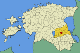
Ülenurme (German: Uellenorm ) is a former municipality in the Estonian district of Tartu with an area of 86.349 km². It has 4743 inhabitants (as of January 1, 2006). It has been part of the rural community of Kambja since 2017 .
Ülenurme is located in the southwest of the district, 6 km from Tartu . In addition to the main town of Ülenurme (1028 inhabitants), the rural community also included the villages of Külitse, Laane, Lätiküla, Lemmatsi, Lepiku, Õssu, Räni, Reola, Soinaste, Soosilla, Täsvere, Tõrvandi and Uhti.
The Estonian Agricultural Museum ( Eesti Põllumajanduse Muuseum ) with around 40,000 exhibits has been located in the former stables of the Ülenurme manor house (built in 1909) .
Web links
- Website of the municipality of Ülenurme (Estonian)
- Estonian Agricultural Museum website (Estonian)

