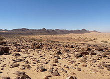
Adrar Plateau

The Adrar Plateau is a highland of the Sahara desert in the center and north of Mauritania .
The plateau is known for rugged rocky hills, steep gorges and walking dunes . The largest city in the region is Atar . In the Adrar area there are 27 oases with a total area of 2200 hectares, which corresponds to 22 percent of the oasis area of Mauritania. The traditional forms of farming are camel and sheep breeding, date palms thrive in the oases, the fruits of which are harvested in July in the hottest season. During this time, the annual rainfall, which is less than 100 millimeters, also falls. Grains and a limited selection of vegetables are grown in irrigation gardens and moist hollows ( sebkhas ) .
Numerous archaeological finds show that the highlands were already settled in the Stone Age, the most important being several stone circles around the medieval city of Azougui .
literature
- Adrar. In: The Encyclopaedia of Islam. New Edition . Brill, Leiden 1986, Vol. 1, pp. 210f
Web links
Individual evidence
- ↑ Tarik Abdullatif: Mauritania's economy under the sign of underdevelopment and dependency. In: Ursel Clausen (Ed.): Mauritania - an introduction. German Orient Institute, Hamburg 1994, p. 113, ISBN 3-89173-037-3
Coordinates: 20 ° 24 ′ 18.6 ″ N , 13 ° 6 ′ 40.1 ″ W.