
Old Saarbrücken cemetery

Main entrance of the old cemetery in Alt-Saarbrücken on Deutschherrnpfad
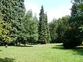
View of the park of the cemetery. The Alt-Saarbrücken cemetery is a former cemetery and is now used as a park.


location
The cemetery is located on a slope in the middle of old Saarbrücken . In the north, Komturstrasse and Deutschherrnpfad border the cemetery, in the west the Strasse Bruchschneidersdell, in the east the Friedhofsallee and Dellengartenstrasse and in the south the Strasse Am Ordensgut.
history
The cemetery was laid out and opened in 1851. Between 1907 and 1909 the area was expanded. When the city's inner-city cemeteries reached their occupancy limits in the 1910s, the city administration decided in 1914 to create a new central burial site in the south of Saarbrücken. In 1917 the cemetery in Old Saarbrücken was then closed.
Today the almost 4 hectare area serves as a park and local recreation facility. It was rededicated in the 1990s. Most of the graves were removed and turned into a park. The few preserved graves are primarily artistically valuable or are under monument protection. For a few graves there is also a right of use; the last burial was carried out in 2002.
Monuments
The cemetery has some pompous tombs of prominent middle-class families, including the Röchling industrialist family, the Kloevekorns , the Haldy merchant family , the Saarbrücken mayor and well-known ornithologist Julius Kiefer and an honorary grave of Charles Rupied . Fallen soldiers from the Franco-Prussian War of 1870/71 and the First World War are also buried here. The site is a listed building.
literature
- Graf, Sabine: City history carved in stone. Article in the Saarbrücker Zeitung from August 9, 2008. Available online via the text archive of the Saarbrücker Zeitung , headline = city history carved in stone.
- The old cemetery is one of the most impressive places in the city , Saarbrücker Zeitung, 23 August 2011.
Web links
- Friedhof Alt-Saarbrücken on the website Saarbrücker Friedhöfe
Individual evidence
- ^ Hans-Walter Herrmann: The collegiate church St. Arnual in Saarbrücken . Rheinland-Verlag, 1998, p. 522.
- ↑ Saarland Monuments List, Saarbrücken Sub- Monument List (PDF; 653 kB), Saarland State Monuments Office, p. 1.
Coordinates: 49 ° 13 '48.9 " N , 6 ° 58' 36.4" E