
Amery Ice Shelf
Coordinates: 69 ° 30 ′ S , 73 ° 30 ′ E


The Amery ice shelf ( English Amery Ice Shelf ) is in East Antarctica located, permanent ice, the Prydz Bay spans. It is formed from the ice surface of the Lambert Glacier , which flows into the sea there. Geographically, it is between 69 ° and 70 ° S and between 72 ° and 75 ° E. The Amery Ice Shelf is located in a tapering bay with a length of 400 km and a maximum width of 175 km. In the west is the Mac-Robertson Land , in the east the American highlands .
After the Ross Ice Shelf and the Filchner-Ronne Ice Shelf , it is the third largest of its kind in the Antarctic with an area of 62,600 km 2 (as of 2007).
The Australian claim to the area was suspended by the Antarctic Treaty .
A large iceberg detaches from the Amery Ice Shelf approximately every 60 to 70 years. The last time this happened was in September 2019; This time the broken ice surface was approx. 50 × 30 kilometers and 200 meters thick; this corresponds to the size of the urban area of London .
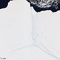
Amery Ice Shelf (satellite image)

Amery Ice Shelf (animation)


Web links
- Ice Shelves Website of the National Snow and Ice Data Center
- Lambert Glacier / Amery Ice Shelf satellite image
Individual evidence
- ↑ Scambos, TA et al., "MODIS-based Mosaic of Antarctica (MOA) data sets: Continent-wide surface morphology and snow grain size" ( Memento of October 27, 2011 in the Internet Archive )
- ↑ Giant iceberg D28 broken off . In: tagesschau.de, October 1, 2019 (accessed October 1, 2019).