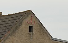
Anker (Magdeburg)
Anker is a part of the Beyendorf-Sohlen district of Magdeburg .
location
It is located west of Beyendorf-Sohlen, directly on the country road leading south from Magdeburg towards Leipzig . For a long time the road was designated as federal highway 71 , but is no longer a federal highway today. South of the armature which extends federal highway 14 and is the community to Sülzetal belonging Dodendorf .
In the district, the street Zum Anker coming from Beyendorf meets the main street known as Leipziger Chaussee . There are only a few houses belonging to the district that run along the main street. A house plot is located on the street Zum Anker.
history
Anker goes back to an inn that was originally located here. It was located on the east side of the Chaussee leading from Magdeburg to Leipzig and is already shown on a map from 1850. At least in the 1930s, the settlement was cartographically referred to as Jägersheim . Together with Beyendorf-Sohlen, Anker was incorporated into Magdeburg in 2001.
economy
At the southern end of Ankers there is a larger horticultural market, the Gartenland Findeklee . An excavator adventure park is operated to the east of the village, and further east there is a sand pit and rubble storage facility.
Individual evidence
- ^ F. Handtke, Map of the Royal Prussian Province of Saxony, the Duchies of Anhalt, the Duke. Saxon states Weimar Altenburg and Gotha and the principalities of Schwarzburg and Reuss , published by C. Flemming, Glogau 1850 (reprint of the year 2000)
- ↑ Measuring table size. Ottersleben from 1936
Coordinates: 52 ° 3 ′ N , 11 ° 37 ′ E

