
Arakao
Arakao (also Arakaou ) is a valley in the east of the high mountains Aïr in Niger . Because of its shape, it is also called Pince de Crabe ( French for "crab claw").
- Arakao in pictures

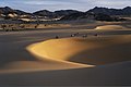
Sand dunes in Arakao.
Crossing the Ténéré desert to the Aïr mountains in Arakao.

Landsat satellite image: top right the circular valley surrounded by “crab claws”.
.jpg)


Arakao is an almost circular valley basin that has an opening to the Ténéré desert in the northeast . This opening is framed by crab claw-shaped foothills of the Takolokouzet Mountains . The name Arakao comes from the Tuareg language . The name Pince de Crabe goes back to the Frenchman Louis-Henri Mouren, who lived in Niamey and who explored the tourist potential of the Aïr region and who flew over the valley in an airplane in 1972.
The valley emerged as the broken caldera of an extinct volcano from the Tertiary and Quaternary periods .
A chain of sand dunes, 15 kilometers long and up to 200 meters high, runs through Arakao and on through the Ténéré plain, and after those of Témet are among the highest in the Ténéré.
Administratively, the valley belongs to the rural municipality of Iférouane in the Agadez region . It is part of the Aïr and Ténéré nature reserve , which has been a UNESCO World Heritage Site since 1991 . Sahara rock carvings and stone tombs from the late Neolithic age have been preserved on the surrounding hills .
Web links
Individual evidence
- ↑ Jolijn Geels: Niger . Bradt, Chalfont St Peter 2006, ISBN 1-84162-152-8 , p. 194 .
- ↑ Harald A. Friedl: The justifiability of ethnotourism using the example of the Tuareg of the Agadez region, Republic of Niger (West Africa) - An evaluation from the perspective of applied tourism ethics. Dissertation . Karl Franzens University Graz, Graz 2005, p. 220 .
- ↑ Dominique Auzias, Jean-Paul Labourdette: Niger . Petit Futé, Paris 2009, ISBN 978-2-7469-1640-1 , pp. 164 .
- ↑ Réserves naturelles de l'Aïr et du Ténéré on the website of the UNESCO World Heritage Center ( English and French )., Accessed on March 19, 2013.
- ↑ Boubé Gado : Paléoenvironnements et occupation humaine des temps préhistoriques à l'epoque contemporaine . In: Franck Giazzi (ed.): La Réserve Naturelle Nationale de l'Aïr et du Ténéré (Niger). The connaissance des éléments du milieu naturel et humain dans le cadre d'orientations pour un aménagement et une conservation durables. Analysis descriptive . Union Internationale pour la conservation de la nature et de ses ressources, Gland 1996, ISBN 2-8317-0249-6 , p. 283 .
- ↑ Dominique Auzias, Jean-Paul Labourdette: Niger . Petit Futé, Paris 2009, ISBN 978-2-7469-1640-1 , pp. 187 .
Coordinates: 18 ° 55 ′ 50 ″ N , 9 ° 36 ′ 5 ″ E