Arizona State Route 98

|
|
|---|---|
| map | |

|
|
| Basic data | |
| Overall length: | 67 mi / 108 km |
| Starting point: |
|
| End point: |
|
| County: | Coconino County |
| Important cities: |
Page Kaibito Shonto |
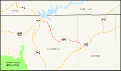
The Arizona State Route 98 (abbreviated AZ 98 ) is a state highway in the US state of Arizona , which runs east-west direction. The approximately 67 mile (108 km) long road begins on US Highway 89 in Page and ends on US Highway 160 east of Cow Springs .
Most of the State Route runs through sparsely populated areas and the Navajo Indian Reservation .


course
Arizona State Route 98 begins south of Page at the junction with US Highway 89 . After a few miles it passes the small village of Lechee . Further east, the road passes Navajo Generating Station to the north and cuts through Antelope Canyon . As far as Kaibito , the route initially runs in a southerly direction parallel to the tracks of the Black Mesa and Lake Powell Railroad . Mainly dry desert areas are crossed. The road then swings in a south-easterly direction and winds in many bends through a hilly landscape. Shortly before the junction with US Highway 160 , AZ 98 passes Shonto in the north .
See also
Web links
- Arizona Roads (English)