Coconino County
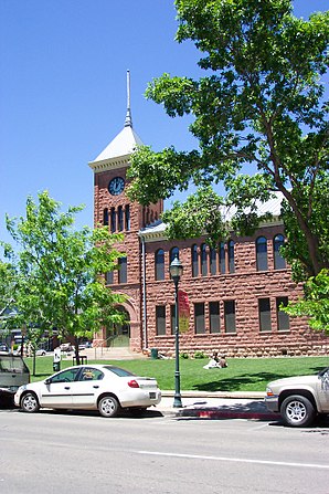
 Old Coconino County Courthouse |
|
| administration | |
|---|---|
| US state : | Arizona |
| Administrative headquarters : | Flagstaff |
| Foundation : | 1891 |
| Demographics | |
| Residents : | 134,421 (2010) |
| Population density : | 2.8 inhabitants / km 2 |
| geography | |
| Total area : | 48,332 km² |
| Water surface : | 113 km² |
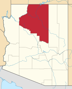
| map | |
| Website : www.coconino.az.gov | |
Coconino County is a county in the northern state of Arizona in the United States . At the 2010 census , the county had 134,421 residents. The county seat is in Flagstaff .
geography
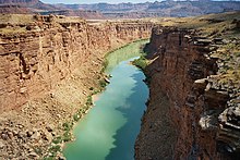
The county is located in northern Arizona and borders Utah to the north . The Colorado River flows through it. The part of the county north of Colorado is part of the Arizona Strip .
Coconino County measures 48,332 square kilometers, 113 square kilometers of which is water. It is the largest county in Arizona and the second largest in the United States.
In the county are part of the Navajo Nation Reservation and the Grand Canyon National Park as well as the Kaibab National Forest with the Red Butte mountain , which is a sacred place for the Havasupai Indians .
Since 1959, the Lowell Observatory has operated a branch called Anderson Mesa Station (IAU Code 688) in Coconino County.
history
The county was established on February 19, 1891. The name comes from the Hopi language and is the modified form of the offensive name for their neighboring tribes. Other translations refer to water .

155 buildings and sites in the county are listed on the National Register of Historic Places (NRHP) (as of May 2, 2020), including the Grand Canyon Lodge , the Grand Canyon Village Historic District , the Lowell Observatory and eight other properties National Historic Landmarks .
Demographic data
| growth of population | |||
|---|---|---|---|
| Census | Residents | ± in% | |
| 1900 | 5514 | - | |
| 1910 | 8130 | 47.4% | |
| 1920 | 9982 | 22.8% | |
| 1930 | 14,064 | 40.9% | |
| 1940 | 18,770 | 33.5% | |
| 1950 | 23,910 | 27.4% | |
| 1960 | 41,857 | 75.1% | |
| 1970 | 48,326 | 15.5% | |
| 1980 | 75.008 | 55.2% | |
| 1990 | 96,591 | 28.8% | |
| 2000 | 116,320 | 20.4% | |
| 2010 | 134,421 | 15.6% | |
| 1900-1990
2000 2010 |
|||

According to the 2000 census , Coconino County had 116,320 people. There were 40,448 households and 26,938 families. The population density was 2 people per square kilometer. The racial the population was composed of 63.09% White, 1.04% African American, 28.51% Native American, 0.78% Asian, 0.09% Pacific Islander, and 4.13% other races Groups; 2.36% were from two or more races. Hispanic or Latino of any race was 10.94% percent of the population.
Of the 40,448 households, 34.90% percent had children and young people under the age of 18 living with them. 49.70% percent were married couples living together, 12.20% percent were single mothers, 33.40% percent were non-families. 22.10% were single households and 4.50% had someone who was 65 years of age or older. The average household size was 2.80 and the average family size was 3.36 people.
For the entire county, the population was composed of 28.70% of residents under the age of 18, 14.40% between 18 and 24 years of age, 29.20% between 25 and 44 years of age, and 20.70% between 45 and 64 years of age 7.00% were 65 years of age or over. The average age was 30 years. For every 100 females there were 99.70 males, and for every 100 females aged 18 and over there were 97.20 males.
The median income for a household in the county is $ 38,256 , and the median income for a family is $ 45,873. Males had a median income of $ 32,226 versus $ 25,055 for females. The per capita income was $ 17,139. 18.20% of the population and 13.10% of families are below the poverty line. 22.30% of them are under 18 years of age and 13.30% are 65 years of age or older.
Places in Coconino County
There are six parishes in Coconino County, four of which are cities and two towns . For statistical purposes, the US Census Bureau maintains 20 census-designated places that are subordinate to the county and are not self-governing. Like the Unincorporated Communities, these are unincorporated areas.
other unincorporated communities
Protected areas
Others
The main inner belt asteroid (2939) Coconino is named after Coconino County. George Herriman's comic strip Krazy Kat is set in a fictional Coconino County .
Individual evidence
- ↑ GNIS-ID: 25443. Retrieved on February 22, 2011 (English).
- ↑ Charles Curry Aiken, Joseph Nathan Kane: The American Counties: Origins of County Names, Dates of Creation, Area, and Population Data, 1950-2010 . 6th edition. Scarecrow Press, Lanham 2013, ISBN 978-0-8108-8762-6 , p. 65.
- ↑ Listing of National Historic Landmarks by State: Arizona. National Park Service , accessed May 2, 2020.
-
↑ Search mask database in the National Register Information System. National Park Service , accessed May 2, 2020.
Weekly List on the National Register Information System. National Park Service , accessed May 2, 2020.
Listing of National Historic Landmarks by State: Arizona. National Park Service , accessed May 2, 2020. - ↑ Extract from Census.gov . Retrieved February 28, 2011
- ↑ Excerpt from factfinder.census.gov.Retrieved February 28, 2011
- ^ Extract from census.gov.Retrieved March 31, 2012
- ^ Coconino County, Arizona , 2000 census datasheet at factfinder.census.gov .
- ^ Lutz D. Schmadel : Dictionary of Minor Planet Names . Fifth Revised and Enlarged Edition. Ed .: Lutz D. Schmadel. 5th edition. Springer Verlag , Berlin , Heidelberg 2003, ISBN 978-3-540-29925-7 , pp. 186 (English, 992 pp., Link.springer.com [ONLINE; accessed on September 23, 2019] Original title: Dictionary of Minor Planet Names . First edition: Springer Verlag, Berlin, Heidelberg 1992): “1982 DP. Discovered 1982 Feb. 21 by E. Bowell at Anderson Mesa. "
Web links
Coordinates: 35 ° 38 ′ N , 112 ° 6 ′ W


