Red butte
| Red butte | ||
|---|---|---|
|
View from the south |
||
| height | 2232 m | |
| location | Arizona , USA | |
| Mountains | Coconino plateau | |
| Coordinates | 35 ° 49 '13 " N , 112 ° 5' 25" W | |
|
|
||
| Type | Zeugenberg | |
| rock | Siliciclastics | |
| Age of the rock | Lower Triassic | |
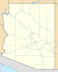
The Red Butte is a mountain in the USA . It is located about 25 kilometers south of Grand Canyon Village in the Kaibab National Forest in Coconino County in the north of the US state Arizona . Its height above sea level is 2232 meters, but it only towers over the surrounding area by around 250 meters.
The mountain lies on the Coconino Plateau, a sub -plateau of the Colorado Plateau . It is constructed from terrestrial siliciclastics from the Triassic Moenkopi Formation . The red color of these sedimentary rocks gives the Red Butte its name. In the area around the mountain, however, there are Permian sedimentary rocks. Because these are less resistant to weathering and erosion than the rocks of the Moenkopi Formation, they are not relief-forming and the Red Butte remained as a witness mountain of a once far more extensive outcrop of the Moenkopi Formation.
On the west side of the mountain there is a path to the top. From there you can see the north edge of the Grand Canyon . The Havasupai Indians consider the mountain to be a holy place.
swell
- Red Butte, Coconino Co., AZ, 7.5-Minute Quadrangle Map. US Geological Survey, Department of the Interior, Washington 2014
- Geological Map of Arizona, 1: 1,000,000. Arizona Geological Survey, Tucson 2000 ( online )

