
Mariagrube station
| Track systems and platforms in the Mariagrube station |
|||||||||||||||||||||||||||||||||||||||||
|---|---|---|---|---|---|---|---|---|---|---|---|---|---|---|---|---|---|---|---|---|---|---|---|---|---|---|---|---|---|---|---|---|---|---|---|---|---|---|---|---|---|
 Station building February 2007
| |||||||||||||||||||||||||||||||||||||||||
1 : shut down in the 1980s |
|||||||||||||||||||||||||||||||||||||||||
| Swell: | |||||||||||||||||||||||||||||||||||||||||
The Mariagrube station was a station belonging to Mariadorf between the Alsdorf districts of Mariadorf and Alsdorf-Ost in the North Rhine-Westphalian city region of Aachen . It was at the northern exit of Mariadorf on the railway underpass under Eschweiler Strasse , from which a small path leads to the station building. Until it was closed, the station was the most important intermediate station on the Aachen North – Jülich line . It should not be confused with the Mariadorf station on the Herzogenrath - Alsdorf - Stolberg ring line . The name comes from the EBV pit Maria .
A Euregiobahn -Haltepunkt Alsdorf Maria village since the end of 2011 in operation.
history
In the winter of 1873/1874, the Aachener Industriebahn Actiengesellschaft began building the Aachen North - Hoengen line, and the station was built in 1875 near the main shaft of the Maria mine. The name of the station comes from the Maria mine. On September 26, 1875 the section Würselen - Hoengen and on December 31, 1875 the section Aachen North - Würselen went into operation.
The Mariagrube station was an operational peculiarity: the Herzogenrath - Alsdorf - Stolberg ring line crossed at this tower station at no elevation . As a result, it had three separate platforms: One on the Aachen North - Jülich line, one on the Herzogenrath - Alsdorf - Stolberg ring line, and one on the connecting curve between the two lines. On the Ringbahn it was just a stopping point, but on the Aachen North - Jülich line it was a train station. The tracks and platforms were not located below the line crossing on a railway embankment, but behind it in the direction of Jülich. There was also a connecting curve (also with a platform) to the Ringbahn, which was only passable from the direction of Jülich and led in the direction of Alsdorf, as well as a branch line to the Emil Mayrisch EBV pit in Siersdorf. This connecting curve to the ring railway to Alsdorf replaced the connecting curve from Stolberg in the 1940 / 50s, which was dismantled at the same time.
The previously mentioned branch line Mariagrube - Siersdorf - Emil-Mayrisch was closed in 1996 after the shutdown of the power station in Siersdorf.
Picture gallery

Shunting area February 2007
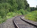
Upper platform of the former Mariagrube station, July 2007


See also
literature
- Bernd Franco Hoffmann: Disused railway lines in the Rhineland. Sutton-Verlag, Erfurt 2014, ISBN 978-3-95400-396-9 .
Web links
- Operating point description of Mariagrube in the NRWbahnarchiv by André Joost
- History of the station
- historical photos
Individual evidence
- ^ German Maps - sheet 5103: Eschweiler. Retrieved September 13, 2015 .
Coordinates: 50 ° 51 '57.9 " N , 6 ° 11' 8.7" E