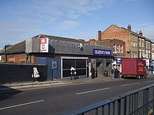
Queen's Park station
Queen's Park is a train station in the London Borough of Brent . It is located at the junction of Salusbury Road and Harvist Road in Travelcard tariff zone 2. The station is served on the one hand by London Overground local trains between London Euston and Watford Junction and on the other hand by the Bakerloo Line of London Underground . Some Bakerloo trains turn around at Queen's Park instead of continuing to Harrow & Wealdstone . In 2014, 5.84 million subway passengers used the station, plus 4.310 million rail passengers.
All platforms in Queen's Park are above ground. The entrance to the inner city tunnel of the Bakerloo Line is around 300 meters east of the station. There is an interesting route to the west of the station: the Bakerloo Line trains run through a depot shed to get onto the railroad tracks in the direction of Watford. Around a third of the underground trains turn in Queen's Park.
The station on the West Coast Main Line , which has existed since 1837, was opened on June 2, 1879 by the London and North Western Railway (LNWR). This began on June 15, 1912, the electrical suburban traffic on parallel tracks (the so-called Watford DC Line ). The Bakerloo Line reached Queen's Park on February 11, 1915. From May 10, 1915, the subway continued on the tracks of the LNWR to Willesden Junction .
Web links
- Departure times and travel information from National Rail
- Photo of the station building (1925)
- Photo of the platforms (1933)
Individual evidence
- ↑ COUNTS - 2014 - annual entries & exits. (PDF, 44 kB) (No longer available online.) Transport for London, 2015, archived from the original on February 21, 2016 ; accessed on December 29, 2017 (English). Info: The archive link was inserted automatically and has not yet been checked. Please check the original and archive link according to the instructions and then remove this notice.
- ^ Estimates of station usage. (Excel, 1.1 MB) Office of Rail Regulation, 2014, accessed on July 27, 2014 (English).
- ^ Bakerloo Line. Clive's Underground Line Guides, accessed January 14, 2013 .
| Previous station | Transport for London | Next station |
|---|---|---|
| Kilburn Park |
|
Kensal Green |
| Kilburn High Road |
Watford DC Line |
Kensal Green |
Coordinates: 51 ° 32 ′ 2 " N , 0 ° 12 ′ 17" W.

