Bayahibe
| Bayahibe | ||
|---|---|---|
|
Coordinates: 18 ° 22 ′ N , 68 ° 50 ′ W Bayahibe on the map of Dominican Republic
|
||
| Basic data | ||
| Country |
|
|
| province | La Altagracia | |
| local community | San Rafael del Yuma | |
| City foundation | 1874 | |
| Residents | 2000 (2009) | |
| Detailed data | ||
| Time zone | UTC −4 | |
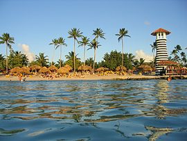
| Beach and bar | ||
Bayahibe is a village in the southeast of the Dominican Republic in the province of La Altagracia about 140 kilometers east of Santo Domingo and about 22 kilometers east of La Romana (this is also the closest larger city). The place has about 2000 inhabitants.
The place is on the coast and was founded in 1874 as a fishing village. Today it is mainly a tourist destination with large hotels and other tourist infrastructure. There are two tourist beaches: Playa de Bayahibe and Playa Dominicus. There are over 20 dive sites off the coast.
Nearby attractions include: Casa Ponce de Leon (home of Ponce de Leo , built in 1505), the Parque Nacional del Este National Park with Isla Saona . The main port for trips to Isla Saona is located at Playa de Bayahibe.

