
Bibi lake
| Bibi lake | ||
|---|---|---|

|
||
| Geographical location | Upper Bavaria | |
| Tributaries | No | |
| Drain | No | |
| Data | ||
| Coordinates | 47 ° 50 '5 " N , 11 ° 28' 17" E | |
|
||
| Altitude above sea level | 599 m | |
| surface | 9.4 ha | |
| length | 480 m | |
| width | 210 m | |
| volume | 960,000 m³ | |
| Maximum depth | 8.6 m | |
| Middle deep | 6.0 m | |

The Bibisee is a groundwater lake that was created between 1969 and 1978 through gravel mining . It is located in the municipality of Königsdorf , in the Wiesen district directly on the B 11 . The lake offers a beautiful panorama of the Bavarian pre-Alps.
Picture gallery
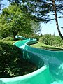
Children's slide on Lake Bibisee

Children's paddling pool at the Bibisee


Use as a bathing lake
The Bibisee is privately owned and fenced. Access to the bathing area with sunbathing area, toilets, showers, water slide, paddling pool and sandpit is chargeable. Monitoring by the water watch is guaranteed. The tests of the bathing water quality in accordance with EC Directive 76/160 / EEC at the Westufer bathing area by the health department have not resulted in any complaints in the past 30 years. There are parking spaces right by the lake.
Web links
Individual evidence
- ↑ District Office Bad Tölz-Wolfratshausen .