
Blasket Islands
| Blasket Islands | ||
|---|---|---|
 |
||
| Waters | Atlantic Ocean | |
| Geographical location | 52 ° 5 ′ N , 10 ° 33 ′ W | |
|
||
| Number of islands | 12 | |
| Main island | Great blasket | |
| Residents | uninhabited | |
 |
||

The Blasket Islands , Irish: Na Blascaodaí [ nə blas'k u e: di: ], are a group of smaller, now uninhabited islands off the tip of the Dingle Peninsula , which in turn belongs to County Kerry in the Republic of Ireland . Of these islands, the five larger ones were inhabited, the seven smaller ones uninhabited. By far the largest island is the Great Blasket Island (Irish: An Blascaod Mór , [ ən 'blaske: d' mo: r ] or [ ə blas'ke: d 'muər ] in Kerry Irish).
history
After some of the islands had been continuously inhabited for several centuries, a decline began in the first half of the 20th century. The Irish state has long ceased to regard living conditions on the islands as humane and appropriate to civilization. In addition, declining fishing quotas and the emigration of younger people resulted in the last 22 residents of Great Blasket Island being evacuated to the mainland in 1953. Other islands have already been emptied.
The way of life on the Blasket Islands is still considered to be very archaic, as it was largely based on barter and the living conditions were comparatively simple, if not primitive. Since the late 19th century, anthropologists , sociologists and linguists have repeatedly focused on these conditions . Inspired by the contacts that came about, some of the Blasket residents wrote authentic descriptions of their lives.
Since the resulting works are largely of an autobiographical nature, they are summarized as Blasket Biographies . Tomás Ó Criomhthain's (Thomas O'Crohan, 1857–1937) autobiography An tOileánach (English The Islandman , Eng. The boats no longer go out ), which was translated into German by Annemarie and Heinrich Böll, is particularly well known .
However, reading these books proves that the inhabitants of the Blasket Islands were nowhere near as severely cut off from the rest of the world as is often claimed. They had close commercial and cultural contacts with various places on the Dingle Peninsula, and later also with crews of trawlers of international origin. In this respect it is also a legend that the residents neither knew nor had money. At least the male population was regionally mobile and therefore dependent on money in other places.
In the 1980s, the abandoned houses were inhabited by a group of dropouts from Germany who lived there from fishing and rabbit hunting. The only connection to the mainland was a small rubber dinghy. During this time wild sheep was farmed on the island.
Since the beginning of 2015 there has been no regular ferry connection from Dún Chaoin to Great Blasket. Boats that orbit the Blasket Group from Dingle Harbor while birdwatching are now docking on Great Blasket when requested. It is necessary to change from the larger boats to an inflatable boat.
The islands

Great blasket
Great Blasket (Irish: An Bhlascaod Mhór ) is the main island of the Blaskets. It is located about 2 km from the Irish "mainland" and extends about 6 km in a south-westerly direction. The highest point is "Croaghmore" at 292 m.
- Blasket Islands

Pier at Dún Chaoin , for boat connections to the islands

Abandoned homes on Great Blasket Island

Beginish - View from Kerry (Great Blasket Island)

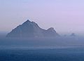
Inishnabro with Tearaght Island in the background

Inishtooskert (the "Dead Man") seen from Beginish

clochan on Inishtooskert
Tearaght seen from Inishtooskert


Beginish
Beginish (Irish: Beiginis ) is a flat, only 14 m high island between Great Blasket and the mainland. There are large colonies of arctic terns and gray seals .
Inishnabro
Inishnabro (Irish: Inis na Bró ) is separated from Inishvickillane by an approximately 200 m wide strait and rises 175 m above sea level.
Inishvickillane
Inishvickillane (Irish: Inis Mhic Uibhleáin ) is home to several colonies of different seabird species. There are also numerous ruins of old stone houses on it.
Inishtooskert
Inishtooskert (Irish: Inis Tuaisceart ) is the northernmost of the Blasket Islands. Because of its characteristic silhouette, it is also known as An fear Marbh (Dead Man). On the 172 m high island there are numerous colonies of sea birds as well as ruins of old stone buildings. A colony of petrels is particularly worth mentioning . With more than 27,000 breeding pairs (as of 2000) it is the largest colony of its kind in Ireland and Great Britain.
Tearaght Island
Tearaght Island (Irish: An Tiaracht), also The Tearaght or Inishtearaght , is the westernmost of the Blasket Islands and also the westernmost point of all of Ireland. The uninhabited, steeply sloping rock island extends around one kilometer in an east-west direction and 500 m in a north-south direction. The highest point is 200 m above sea level. As on the other Blasket Islands, there are also numerous sea birds here. Colonies of Atlantic shearwaters and petrels are important. Wave walkers can also be observed, but do not seem to breed here.
In 1879 a lighthouse was built on Tearaght Island, which was automated in 1988.
Web links
- English-language information on the history, culture and people of the Blasket Islands on dingle-peninsula.ie/
- Jörg Pfeiffer: Great Blasket Island: the weaver's island . Film on Spiegel Online; Retrieved November 3, 2014