Bloodtip
| Bloodtip | ||
|---|---|---|
|
Bloodtip |
||
| location |
|
|
| Coordinates | 22 ° 50 '30 " S , 15 ° 22' 59" E | |
|
|
||
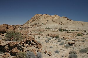
The Blutkuppe (rarely also Blutkoppe or Afrikaans Bloedkoppie ) is an island mountain made of granite in the Namib of Namibia . It is named after the blood-red discoloration at sunrise and sunset. From the summit of the Blutkuppe you have a good view of the Namib.
The Langer Heinrich uranium mine is located about five kilometers northwest of the Blutkuppe .
literature
- Gabi Schneider: The Roadside Geology of Namibia. Gebr. Borntraeger, 2004, ISBN 3-443-15084-5 , p. 140.
- Stefan Porembski, Wilhelm Barthlott: Inselbergs: Biotic Diversity of Isolated Rock Outcrops in Tropical and Temperate Regions. Springer-Verlag, Berlin / Heidelberg 2000, ISBN 3-642-64120-2 .
Web links
Commons : Blutkuppe - Collection of pictures, videos and audio files

