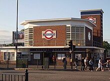
Bounds Green (London Underground)
Bounds Green is an underground station on the London Underground in the London Borough of Haringey . It is on the border of the Travelcard tariff zones 3 and 4, at the intersection of Bounds Green Road and Brownlow Road. Trains of the Piccadilly Line run here . In 2013, 6.16 million passengers used this station served by the Piccadilly Line.
Like all stations in the northern part of the Piccadilly Line, this one was designed by Charles Holden . The station building is a well-preserved example of the Modernist style for structures along the Piccadilly Line. The dominant building materials are red and brown bricks and steel frames that frame the large windows. The octagonal counter hall is flanked in the north by a shop wing and in the north by a high ventilation shaft. The building has been a listed building ( Grade II ) since 2010 .
The station opened on September 19, 1932, when the Piccadilly Line was extended from Finsbury Park north to Arnos Grove . Wood Green North and Brownlow Road were originally also mentioned as station names . On October 13, 1940, a German aerial bomb hit two three-story houses not far from the station. The northern end of the platform leading towards Wood Green also collapsed. According to the Commonwealth War Graves Commission , 16 people were killed, including three war refugees from Belgium (however, the plaque placed in the station in 1994 speaks of 16 Belgian and three British victims). The damage was so great that normal operations could only be resumed after two months. Due to the terrorist attacks on July 7, 2005 , the station was closed for a few weeks; it reopened on August 4th.
In 2007 the station was completely renovated as part of an investment program by Transport for London. The work took place at night and on some weekends, for which the station had to be temporarily closed. The focus of the work was the restoration and restoration of the original condition of the listed building. Nevertheless, the underground station was equipped with modern technology, including video surveillance, information pillars and digital train destination displays .
Web links
Individual evidence
- ↑ 2013 annual entries and exits. (Excel, 228 kB) Transport for London, 2014, accessed on July 27, 2014 (English).
- ^ Bounds Green Underground station. In: National heritage list of England. National Heritage, accessed January 26, 2013 .
- ↑ a b Piccadilly Line. Clive's Underground Line Guides, accessed January 26, 2013 .
- ↑ Analysis of casualty and fatality figures. The Underground at war, accessed January 26, 2013 .
- ^ Station Refurbishment Summary . London Underground Railway Society. July 2007. Retrieved March 13, 2015.
| Previous station | Transport for London | Next station |
|---|---|---|
| Wood Green |
|
Arnos Grove |
Coordinates: 51 ° 36 '24.7 " N , 0 ° 7' 27.9" W.

