
Cameroons


Cameroons , often referred to as British Cameroon in German texts , was part of the British Empire in Central Africa from 1916 to 1961 . The area, which today makes up a small part of Cameroon and Nigeria , was a B League of Nations mandate from 1922 to 1946 and a UN trust area from 1946 to 1961 .
After the German colony of Cameroon was occupied by British, French and Belgian troops during the First World War , it was divided into a French and a British mandate by the League of Nations in 1922 . The French part of Cameroun occupied four fifths, the British Cameroons were divided into a north and a south part. With the establishment of the United Nations , the mandates were converted into trust areas.
The French part became independent on 1 January 1960 as Cameroon, the Muslim northern part of British Cameroon decided in a referendum in February 1961, joining Nigeria, which took place on May 31, the 1,961th The southern part became part of Cameroon on October 1st. In the following years there was a dispute over the Bakassi Peninsula in the south of the former British Cameroon, which has its origins in the demarcation of the border between Great Britain and France. In Cameroon, the former southern part of the Republic of Ambazonia has also been fighting for its independence since 1999.
Postage stamps
Prior to the 1961 split, Nigerian postage stamps imprinted with "Cameroons UKTT" were used.

Shilling stamp canceled in Mubi , now in Nigeria

Threepence stamp, canceled in Kumba , now in Cameroon
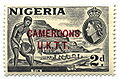
Unvalidated 2d Cameroons stamp


literature
- Engelbert Mveng : Histoire du Cameroun. Présence africaine, Paris 1963.
- Victor Julius Ngoh : Cameroun 1884-1985. Cent ans d'histoire. CEPER, Yaoundé 1990.
- Mark D. DeLancey , Rebecca Neh Mbuh (Ed.): Historical Dictionary of Cameroon (= African Historical Dictionaries. Volume 113). 4th edition. Scarecrow Press, Lanham 2010, ISBN 978-0-8108-5824-4 .