Bakassi Peninsula
The Bakassi Peninsula is an area of around 1000 km² in the Gulf of Guinea . The peninsula , which is rich in fish and oil , is often compared to Kuwait in terms of its potential importance and was the subject of a border conflict between Cameroon and Nigeria in the 1990s . The International Court of Justice ruled in 2002 that it belongs to Cameroon. In August 2008, Nigeria transferred the territory to Cameroon.
geography
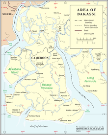
The Bakassi Peninsula lies between the Cross River Estuary in the west and the Rio del Rey Estuary in the east, which are connected by canals. It is located in the tropics and is covered by mangrove swamps . In the west, Akwabana Creek separates the smaller island Akwabana , in the east is the Erong peninsula . The largest villages are Idabato, Jabama, Forisane and Kombo a Munja. The westernmost point of Bakassi is called Sandy Point , the easternmost Cape Bakassi .
At the time of the Nigerian rule, the peninsula was the southernmost of the 18 Local Government Areas of the State of Cross River . In the penultimate Nigerian census in 1991, the area had 3,827 inhabitants and thus a population density of 6 inhabitants per km². According to a data from 2008, the area has up to 300,000 inhabitants, of which around 30,000 were resettled to Nigeria after the handover to Cameroon. The residents of Bakassi belong to the Efik people .
history
Around 1450, a kingdom was founded on Bakassi, which was part of the Kingdom of Calabar and was subordinate to the Obong of Calabar. He concluded a trade agreement in 1882 and a protection treaty with Great Britain in 1884 , in which the Obong's claim to dispose of the peninsula was guaranteed. In 1913, however, Great Britain signed a border treaty with the German Empire , which awarded the Bakassi Peninsula to the German colony of Cameroon without taking into account the claims of the local rulers. The affiliation of the southern part of the British mandate to Cameroon was confirmed in a referendum in 1961 and in 1975 with the Maroua Declaration between the heads of state Ahmadou Ahidjo (Cameroon) and Murtala Mohammed (Nigeria). However, the Maroua Declaration was no longer ratified by his successor Olusegun Obasanjo after the death of Muhammad .
Border conflict
Although Nigeria recognized the colonial borders when the now-defunct Organization for African Unity (OAU) was founded, the Bakassi Peninsula was coveted for its fish, gas and oil wealth and its strategic location as well as for domestic political reasons. After military incidents had already occurred in 1981 and 1991, Nigerian police patrols landed on Bakassi in autumn 1993 and then troops in January 1994 and occupied two offshore islands. The Nigerian government justified this with the killing of six Nigerian fishermen by the Cameroonian armed forces. There were then several skirmishes that resulted in a total of 46 deaths, and again in February and April 1996 to major skirmishes in which some soldiers were killed and many injured. According to Nigerian sources, Cameroon also brought together 5,000 soldiers in spring 1998, but there are no reports of military incidents.
Despite an assistance pact with Cameroon, France did not support the country militarily, but only advocated negotiations in the UN Security Council ; Togo's head of state Gnassingbé Eyadéma offered himself as a mediator. In 1994, Cameroon took the conflict to the International Court of Justice , which ruled in favor of Cameroon in October 2002, but rejected Cameroonian claims for compensation. Although both countries had promised to accept the binding judgment of the International Court of Justice after a meeting in Paris, Nigeria rejected it. Only after several meetings of the respective presidents under the auspices of the UN Secretary-General Kofi Annan , at which the formation of a Bakassi Commission was decided, did Nigeria hand over the Bakassi Peninsula to Cameroon in August 2006 and withdraw its around 3,000 soldiers. After the withdrawal of Nigerian troops in August 2006, clan chiefs tried to proclaim the island's independence as the Republic of Bakassi. The western part remained under Nigerian administration for two years.
On August 14, 2008, the Bakassi Peninsula was completely handed over from Nigeria to Cameroon under strict security precautions.
See also
Web links
- Lukong Pius Nyuylime: Bakassi. Découvrez la péninsule - Discover the Peninsula. From: Cameroon Tribune (June 19, 2007) (French / English)
- Judgment of the ICJ (French / English; PDF file; 18.15 MB)
- BBC report on the resettlement of people from Bakassi to Nigeria (English)
Individual evidence
- ^ The 774 Local Governmnent Areas. Bakassi Local Government Area. Nigeria Congress Online, archived from the original on December 31, 2003 ; accessed on March 24, 2007 (English).
- ↑ a b Nigeria cedes Bakassi to Cameroon BBC August 14, 2008 (English)
- ↑ http://www.akuf.de/
Coordinates: 4 ° 33 ' N , 8 ° 37' E


