Buarbreen
| Buarbreen | ||
|---|---|---|
|
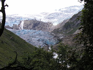
The Buarbreen from the valley |
||
| location | Vestland ( Norway ) | |
| Mountains | Scandinavian mountains | |
| Coordinates | 60 ° 3 ′ N , 6 ° 25 ′ E | |
|
|
||
The Buarbreen (often also Buerbreen) is the name of a glacier west of the town of Odda in Norway .
It designates part of the Folgefonna . According to the UNESCO classification system, it is a glacier of type 434. This means that it has a glacier runoff, a larger ice mass or ice cap (4) with a single firn surface (3) and an ice fall / ice step (4).
location
The part of the Folgefonna, which flows between the two peaks Reinanuten and Nordbakkennuten eastwards into the Buertal, is called Buarbreen . Today it has three clearly formed glacier tongues, which flow over an abrupt edge into the valley and thus change into the shape of a valley glacier. The two larger glacier tongues are called Nedre Buerbreen and Øvre Buerbreen .
The Buarbreen forms one of the 27 hydrological areas of the Follow vonna. The area of the Folgefonna immediately to the south has no name of its own, while the area immediately to the north is called Ruklebreen. The water flows from all three sub-areas into the Sandvinvanten, which is why all three areas in the specialist literature have the same water number 048.B1. When measuring using a flight photo from August 17, 1981, the highest point is given as 1640 m above sea level and the lowest as 620 m above sea level.
Partial glacier
The three partial glaciers form at heights between 1300 and 1400 meters from the nutrient area of the Buarbreen, thus in the immediate vicinity of the equilibrium line, which in 1988 was 1350 meters above sea level. M has been set.
The Nedre Buerbreen , which forms the southernmost of the glacier tongues, extends the furthest into the valley. It also has the steepest ice break, which today even flows around a ledge. However, the ice masses are coherent and form a real valley glacier at the foot. When it was measured in 1981, the glacier tongue was at 620 m. ü. M., on the map from 2005 at approx. 680 m. ü. M. The Øvre Buerbreen is the middle tongue of the glacier; it doesn't have to climb quite as steep a step as the Neder Buerbreen . With its very rugged surface, it flows into the valley without any major changes in gradient. Its course overcomes around 400 meters in altitude and thus ends around 200 meters higher than the Nedere Buerbreen . The Øvre Buerbreen ends on the map from 2005 at around 900 m. ü. M. The northernmost glacier tongue is very small and unnamed. It flows about 200 meters into the valley and ends on the map from 2005 at around 1080 m. ü. M. This glacier tongue has almost no meltwater runoff. The meltwater from the Øvre Buerbreen flows north to the Nedre Buerbreen , where it joins the meltwater from the Nedere Buerbrenn almost directly at the glacier tongue . Here there is and has always been the danger that an unstable meltwater lake will form when the Nedre Buerbrenn advances . The two outflows unite to form Buerelvi , which flows through Buertal into Sandvinvanten. From there it reaches the Oddafiord and the sea via the Opo .
literature
- Atlas over Breer I Sor-Norge Published by Norges Vassdrags- og Energiverk Vassdragsdirektoratet 1988, pages B-46 and B-47
source
- The Turkart 1: 50,000 Folgefonna Nasjonalpark from 2006 was used as the map for spellings and heights, the 50,000 on official Norwegian maps (1315 III, 1315 IV, 1314 IV, 1214 I, 1214 IV, 1215 I - IV) from 2005 is based.
Individual evidence
- ↑ Notation in Atlas over Breer I Sor-Norge


