California State Route 177

|
|
|---|---|
| map | |

|
|
| Basic data | |
| Overall length: | 27.02 mi / 43.48 km |
| Starting point: |
|
| End point: |
|
| County: | Riverside |
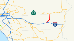
The California State Route 177 (abbreviated CA 177 ) is a state highway in the US state of California , which runs from south to north direction.
The State Route begins on Interstate 10 in the small community of Desert Center and ends near Rice on California State Route 62 . It crosses some of the most deserted and desolate points in the Mojave Desert . The State Route runs along the eastern foothills of Joshua Tree National Park .
See also
List of state, US, and interstate highways in California
Web links
Commons : California State Route 177 - Collection of Pictures, Videos, and Audio Files
- California @ AA Roads route description with photos
- California Highway