
Camus Cross

The Camus Cross (also called Camuston or Camustane Cross) is a stone cross, believed to be from the 10th century, about 4 kilometers northwest of Carnoustie in Angus in Scotland . Mentioned as early as the 15th century in a legal document describing the boundaries between Camuston and the Barony of Downie, the cross is a rare freestanding cross in Eastern Scotland and was first described by Robert Maule in the 17th century. It stands in the center of an avenue about a kilometer long that runs through Camuston Wood in the Downie Hills.
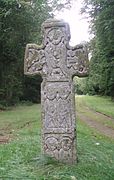
The approximately 2.0 meter high cross stands on an approximately one meter high mound of 7.5 × 4.5 meters. It is 0.2 meters thick, 0.6 meters at the base and 0.8 meters wide on the arms. It. All sides are sculpted. The cross made of Old Red Sandstone, which is heavily weathered, especially on the west side, has lost some scratches. The stone does not bear any Pictish symbols and is a Class III stone according to the classification system of J. Romilly Allen (1847–1907) and Joseph Anderson (1832–1916). Intact free-standing crosses of this age are comparatively rare, and in Eastern Scotland the Camus Cross and Dupplin Cross in Strathearn are the only ones.
The west side is divided into three parts. The top area is almost completely weathered. The archaeologist Alexander Gordon, who described the stone in his Itinerarium Septentrionale in 1726 , understood this panel as a crucifixion scene. Below is the depiction of a centaur holding a bow. The bottom panel shows a symmetrical flower design.
- Camus Cross
East Side

Hogback from Brechin

detail


The east side was described by Robert Maule in the earliest description of the stone as a scene in which Moses introduces the law. Today it is interpreted as a representation of Christ flanked by angels above the four evangelists.
The carvings of the Camus cross show similarities to those on the Hogback of Brechin and suggest Irish influence. The shapes on the north and south edges consist of tendrils and volutes with a "wave crest" thickening. These bear the greatest resemblance to Irish art of the late 10th century. The full-face figures on the east side are identical to those on the Brechin Hogback. On the Hogback of Brechin the figures carry objects that are characteristic of early medieval Irish monasticism.
Tradition holds the cross for the burial place of Camus, the leader of a Norse army, who was defeated by King Malcolm II in 1010 at the Battle of Barry (see Battle Stone of Mortlach ). However, the stone's name probably comes from the abandoned village of Camuston, whose name is of Celtic origin.
literature
- Anna Ritchie, Graham Ritchie : Scotland. Archeology and Early History. Thames and Hudson Ltd., London 1981, ISBN 0-50002-100-7 , ( Ancient places and people ).
Web links
Coordinates: 56 ° 31 '50.3 " N , 2 ° 47' 0.8" W.