Char Nuur
| Char Nuur | ||
|---|---|---|

|
||
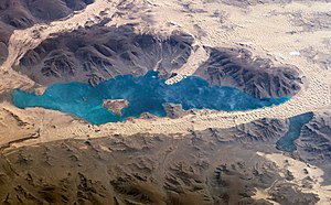
| Char Nuur, the Black Sea, photographed from space by the crew of the International Space Station (2006) | ||
| Geographical location | Mongolia | |
| Data | ||
| Coordinates | 48 ° 21 '0 " N , 96 ° 6' 0" E | |
|
|
||
The Char Nuur , ( Mongolian Хар нуур , Black Lake ) is located in western Mongolia , on the southeastern edge of the "Basin of the Great Lakes". It is part of a group of lakes that are located in the predominantly southeast-northwest and east-west trending tectonic depressions. Original assumptions by Russian scientists from the 1950s that the lakes were connected by a single, large paleo lake during the Holocene or Pleistocene , have now been refuted (Grunert 2009). In addition, such a connection is not conceivable simply because of the strong relief and different elevation. However, larger local lakes have been found in the region for the periods mentioned. The Char Nuur is fed by various streams from the Changai Mountains . On the other hand, the on-site precipitation would be far too low to maintain the lake level. At the moment the lake level seems to be rising, which can be proven by satellite images. Some dunes, which have probably been on dry land since the middle Holocene, are currently drowning. The Char Nuur is a resting place for migratory birds on their way through Central Asia .
literature
- J. Grunert, C. Stolz, H. Hempelmann, A. Hilgers, D. Shell, F. Lehmkuhl, T. Felauer, D. Dasch: The evolution of small lake basins in the Gobi desert in Mongolia. In: Quaternary Sciences. Volume 29, No. 4, 2009, pp. 677-686.
- M. Klein: Inland dunes in northern Central Asia. (= Geographical Studies in Mainz. 47). 2001, DNB 964686449 .
Web links
- Har Nuur ( August 2, 2007 memento on the Internet Archive ) at NASA Earth Observatory.
- Sand dunes in Har Nuur (Black Lake), Western Mongolia
- Satellite image of the week: Ancient lake between shifting dunes
