
Chatham Island
| Chatham Island | ||
|---|---|---|
 |
||
| Waters | Pacific Ocean | |
| Archipelago | Chatham Islands | |
| Geographical location | 43 ° 54 ′ S , 176 ° 32 ′ W | |
|
||
| surface | 899 km² | |
| Highest elevation | Maungatere Hill 294 m |
|
| Residents | 564 (2006) <1 inh / km² |
|
| main place | Waitangi | |
 |
||

Chatham Iceland (Moriori: Rekohu ; Māori : Wharekauri ) is the largest island in the archipelago of to New Zealand belonging Chatham Islands in the southwestern Pacific .
geography
The T-shaped, 899 km² island is characterized by two large bays, Petre Bay in the west with the main town Waitangi and the over 35 km long Hanson Bay in the east. In between is the 179 km² Te Whanga lagoon , which is only separated from the sea by land bridges. The south of the island is occupied by a high plateau and in Maungatere Hill reaches a height of 294 m above sea level. There are also peatlands and long sandy beaches. Tuuta Airport ( IATA : CHT, ICAO : NZCI) is located on a peninsula protruding into the lagoon .
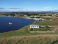
Main town Waitangi

Web links
- Chatham Islands - Natural Heritage . Kiwi Favorites,accessed on January 5, 2016(English, blog with various articles on the subject).