Te Whanga Lagoon
| Te Whanga Lagoon | ||
|---|---|---|

|
||
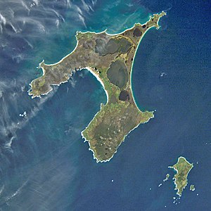
| Satellite image of Chatham Island, Te Whanga Lagoon occupies the center of the island | ||
| Geographical location | Chatham Island , New Zealand | |
| Tributaries |
Te Awainanga River Mangatu Stream Nukuau Creek Oningi Creek Waitamaki Creek |
|
| Drain | Hikurangi Channel → Hanson Bay → Pacific Ocean | |
| Islands | Moropunga I., Titihaukai I., Motuhinahina I. | |
| Location close to the shore | Waitangi | |
| Data | ||
| Coordinates | 43 ° 50 ′ S , 176 ° 27 ′ W | |
|
|
||
| surface | 179 km² | |
| length | 27.1 km | |
| width | 14.1 km | |
The Te Whanga Lagoon is a lake on Chatham Iceland in the South Pacific off the east coast of New Zealand .
With an area of 179 km², the lake dominates the landscape in the interior of the 899 km² island. The lake collects the runoff from several small rivers of the island's southern hill country, including the Awainanga River and the Mangatu Stream . The water runs through several channels into Hanson Bay on the east coast of the island into the Pacific.
Fossilized shark teeth are found on the shores of the lake.
There are a few islands in the lake including Waikawa Island , Moturangaranga Island , Motuhinahina Island, and the Limestone Rocks .
Individual evidence
- ↑ topographic map series NZtopo50, sheets CI103 to CI05.
