Chjargas Nuur
| Chjargas Nuur | ||
|---|---|---|

|
||
| Geographical location | Uws-Aimag ( Mongolia ) | |
| Tributaries | Nuuryn-Choloi , from Airag Nuur | |
| Drain | drainless | |
| Data | ||
| Coordinates | 49 ° 10 ′ N , 93 ° 21 ′ E | |
|
|
||
| Altitude above sea level | 1028 m | |
| surface | 1 360 km² | |
| Maximum depth | 80 m | |

|
||
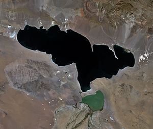
| Landsat satellite image | ||
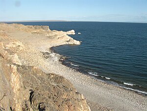
The Chjargas Nuur ( Mongolian Хяргас Нуур ; Russian Хяргас-Нуур ) is an outflow-free salt lake in northwestern Mongolia .
The lake is located at an altitude of 1028 m in the Chjargas Basin in the Great Lakes Basin . The water area is 1360 km². The maximum water depth is 80 m. The content of dissolved solids in the water is 7.5 g / l. The lake surface freezes between November and April. The flat coast mostly borders on the desert . There are only some areas of meadow on Chjargas Nuur. The lake is rich in fish (the carp fish Diptychus maculatus and other fish species). Not far from the south bank is the smaller lake Airag Nuur , which has an outlet to the Chjargas Nuur.
Web links
Commons : {Chjargas Nuur - collection of images, videos and audio files
Individual evidence
- ↑ a b c d e f g h i j Article Chjargas Nuur in the Great Soviet Encyclopedia (BSE) , 3rd edition 1969–1978 (Russian)
- ↑ Article Chjargas-Senke in the Great Soviet Encyclopedia (BSE) , 3rd edition 1969–1978 (Russian)
