Cocos Island (Guam)
| Cocos Island | ||
|---|---|---|
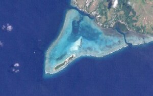
| NASA satellite image of Cocos Island (center) | ||
| Waters | Pacific Ocean | |
| Archipelago | Mariana Islands | |
| Geographical location | 13 ° 14 '10 " N , 144 ° 38' 56" E | |
|
|
||
| length | 1.6 km | |
| width | 300 m | |
| surface | 38.6 ha | |
| Residents | uninhabited | |
| Nautical map of the Cocos Lagoon and Cocos Island | ||
Cocos Island ( Chamorro : Islan Dåno ) is an uninhabited island in the Cocos Lagoon 1.6 km southwest of Guam . The 300 m wide and 1.6 km long island is the southernmost island of the Mariana Islands and has an area of almost one square kilometer.
history
The United States Coast Guard operated the LORAN Barrigada station on the island between 1944 and 1963 . The station's electrics and transformers have weathered over the years and have led to severe PCB pollution in the Cocos Lagoon, located between Guam and Cocos Island. The limit values for PCBs in the water and the fish caught here are still significantly exceeded today.
tourism
There is a hotel complex for vacationers on the west side of Cocos Island.


