Coillenaborgie
Coordinates: 58 ° 29 '46 " N , 4 ° 16' 54" W.
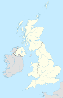
The Cairns of Coillenaborgie (also Allt Ach Coile Na Borgie) are located in the county of Sutherland in the Scottish Highlands , on the southern outskirts of Borgie, about five kilometers from the Scottish Atlantic coast - Torrisdale Bay - with the mouth of the River Borgie .
location
On the southern outskirts of the hamlet-like settlement of Borgie is the confluence of the local road with the A836 and road bridges over the River Borgie , which you have to cross in a westerly direction. About 200 meters west of the bridges is the entrance to a still active quarry on the right of the A836. The objects are located on both sides of the driveway and extend parallel to the street.
description
Coillenaborgie North
The shape of the heavily disturbed, originally about 48 m long Horned Cairn of the Orkney – Cromarthy (OC) Passage tombs type can hardly be reconstructed due to stone removal. The polygonal chamber is filled with all kinds of rubbish.
Coillenaborgie South
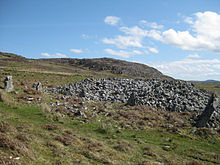
The second, massive megalithic complex of the same type is only ten meters away. Its length could be reconstructed to 72 m due to the existing curb stones. On the wider side (in the north), so-called horns, together with the front of the hill, form an approximately rectangular forecourt, which measures around 18 m. Six of the monoliths, some two meters high, that formed the facade, have been preserved. They represent an unusual architectural element for the north of Scotland. There is also a forecourt at the other end. There are still three monoliths here. An unusually long corridor, of which a few stones have been preserved, leads to the former chamber, which has been stripped of almost all stones and which apparently had a smaller antechamber.
The axis of the chambers and the long corridor is (similar to Skelpick Long ) at an obtuse angle to the axis of the cairn raised from rubble. Presumably here too, as with the Cairns of Camster and the Cairns of Cnoc Freiceadain in the nearby county of Caithness, a former round cairn (Rundcairn) became a long hill through overbuilding.
literature
- Audrey S. Henshall, JN Graham Ritchie: The Chambered Cairns of Sutherland. An inventory of the structures and their contents . Edinburgh University Press, Edinburgh 1995, ISBN 0-7486-0609-2 .
- Robert Gourlay, Sutherland - a historical guide , Birlinn, Edinburgh, 1996 ISBN 1-874744-44-0 pp. 22-23
Web links
- Description Engl. and picture
- Entry on Coillenaborgie in Canmore, the database of Historic Environment Scotland (English)
Individual evidence
- ↑ Achanlochy Quarry
- ↑ in British cards with Earthwork referred
- ↑ Online map service for the UK ( Memento of the original from April 30, 2012 in the Internet Archive ) Info: The archive link was inserted automatically and has not yet been checked. Please check the original and archive link according to the instructions and then remove this notice. - at Search Borgie enter

