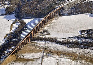
Culloden Viaduct
Coordinates: 57 ° 28 ′ 41 ″ N , 4 ° 3 ′ 45 ″ W.
| Culloden Viaduct | ||
|---|---|---|
| Official name | Culloden Viaduct | |
| use | Railway bridge | |
| Convicted | Highland Main Line | |
| Subjugated | Nairn | |
| construction | Stone arch bridge | |
| overall length | 549 m | |
| Number of openings | 29 | |
| start of building | 1893 | |
| completion | 1898 | |
| opening | November 1, 1898 | |
| planner | Murdoch Paterson | |
| location | ||
|
|
||
The Culloden Viaduct is part of the Perth - Inverness ( Highland Main Line ) railway line in Scotland, which swings out about nine kilometers east of Inverness to cross the River Nairn at Culloden . It leads past the ancient tombs of Clava and is therefore also called the Clava Viaduct ; other names are Culloden Moor Viaduct or Nairn Viaduct .
The viaduct was built by Charles Brand & Sons in 1893–1898 under the direction of John Fowler and Murdoch Paterson . It is the longest railway viaduct in Scotland.
It has 28 stone arches, each 15.24 m wide, and a main arch over the river of 30.48 m wide. The construction of the 39 m high viaduct is simple and without any decorations. Only the pillars of the main arch were emphasized.
The viaduct was included in the Scottish monument lists in the highest category A in 1971.
Web links
- Culloden Viaduct. In: Structurae
- Entry on Culloden Viaduct in Canmore, Historic Environment Scotland database

