Curtis Island
| Curtis Island | |
|---|---|
| The crater on Curtis Island | |
| Waters | Pacific Ocean |
| Archipelago | Kermadec Islands |
| Geographical location | 30 ° 32 '28 " S , 178 ° 33' 26" W |
| length | 867 m |
| width | 600 m |
| surface | 40 ha |
| Highest elevation | 137 m |
| Residents | uninhabited |
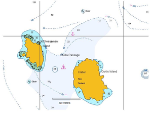
| Map with Curtis Island in the southeast and Cheeseman Island in the northwest | |
Curtis Island is an uninhabited volcanic island in the southwestern Pacific . It is separated from Cheeseman Island, about 500 meters northwest, by the Stella Passage and, like this, part of the Kermadec Islands administered by New Zealand . Both islands, together called Curtis Islands , are located on a ridge, otherwise about 500 meters below the sea surface, the Kermadec Ridge . The Stella Passage is 18.3 to a maximum of 24 meters deep and has strong currents.
Curtis Island is about 35 kilometers south of Macauley Island and about 150 kilometers southwest of the main island of Raoul . With a land area of 0.4 km², it is the third largest of the Kermadec Islands and reaches a height of 137 meters above sea level. Almost the entire northern part of the island is occupied by a volcanic crater 300 to 400 meters long and about 200 meters wide , the bottom of which is about 10 meters above the sea surface. Fumaroles are active in the crater . There are no known eruptions of the volcano in historical times; it is uncertain whether there were submarine eruptions in the vicinity of the island in 1936 and 2009 . In the last 200 years, the island has about 18 meters lifted . Because of the uplift and active fumaroles, Curtis Island is classified as a potentially active volcano.
Macdonald Cove in the north of the island was a bay where boats could land. Due to the uplift of the island, the former bay is now dry land.
The island is named after an officer of the British ship Lady Penrhyn , from which the island was discovered in the late 1780s.
The radius of 12 nautical miles around the island is part of the 7450 km² Kermadec Islands Marine Reserve, which is administered by the Department of Conservation . The island can only be entered with a special permit and only for scientific purposes. It is densely populated by sea birds.
Web links
- Curtis Island in the Global Volcanism Program of the Smithsonian Institution (English)
- Kermadec Marine Reserve (Department of Conservation )
Individual evidence
- ^ Curtis Island - Eruptive History in the Global Volcanism Program (accessed January 10, 2013).
- ^ John H. Latter, Edwards F. Lloyd, Ian EM Smith, Simon Nathan: Volcanic Hazards in the Kermadec Islands, and at submarine volcanoes between southern Tonga and New Zealand. at the Institute of Geological and Nuclear Sciences (accessed January 10, 2013).


