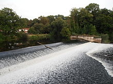
Döhrener mill
The Döhrener Mühle was a historic watermill on the Leine island Döhren an der Leine in the Döhren district of the city of Hanover .
history
The undershot mill, first mentioned in a document in 1402 , was initially owned by the Counts of Hallermund and later by the Welfs . The associated Mühlenhof came to the Döhren Church around 1507 . In 1597 the property was renovated and expanded with the support of the city of Hanover. In the middle of the 17th century it was bought by the merchant Johann Duve . Under his direction, a new weir was built in 1667 and the mill was expanded again. The associated increase in the water level further up the river and the rise in the groundwater level in the river fringes had a significant impact on the Leinemasch ecosystem. Despite his investments, Duve went bankrupt. The mill was bought by Johann von Terener for 4600 Reichstaler. In 1703 the City of Hanover bought it with all accessories for 16,000 Reichstaler and leased it. From 1820 to 1872 Johann Friedrich Fiedeler was the tenant of the mill. His son Carl Georg Fiedeler was able to buy it in 1850. In 1868 it became the property of the Döhrener wool laundry , which mostly demolished the mill buildings and had the area built on by an industrial complex. Fiedeler formed the manor Döhren I from the remaining land and other land acquisitions . The last remnants of the mill yard were removed after the production of Döhrener wool in 1976/77. The Leine weir systems were also demolished in 2004 despite being listed as a historical monument and replaced by a simple concrete barrage.
The street Döhrener Mühle is reminiscent of the former location.
literature
- Helmut Flohr: Right and left of the line. Searching for traces in the Leinemasch between Döhren and Koldingen. Laatzen-Grasdorf 2012, pp. 53–58
- Paul Theile: Kronsberger mill history (= Kronsberger history sheets 2). Hanover 1996
Individual evidence
Coordinates: 52 ° 19 ′ 58.3 " N , 9 ° 45 ′ 35" E

