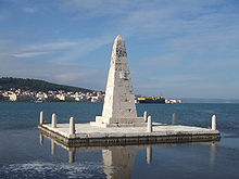
De Bosset Bridge
The De Bosset Bridge (formerly Drapano Bridge) is a stone bridge built in 1813 over the Bay of Argostoli on Kefalonia . At 689.9 meters, it is the longest stone sea bridge and as such was entered in the Guinness Book of Records in 2018 . One of the 16 arches of the bridge is locked, they only protrude a few meters above the surface of the water.
background
The Republic of the Ionian Islands was under British protection and part of the occupation costs were reimbursed in the form of infrastructure projects. With the Swiss Charles de Bosset in 1810 an engineer became island governor, he put the focus of his work on road and bridge construction. Numerous connections were shortened with bridges over gorges. The largest project, however, was the bridge over the bay from Argostoli to Drapano, which shortened the route to Lixouri and the north of the island. It roughly separates the Koutavos lagoon from the bay.
The bridge has never been given a name, at first it was named after the northern end point in Drapano, in dialect it was called Pontes (Πόντες) and for several decades the name De-Bosset has been used, after the builder. Officially, the street was only viewed as a street section, then an attempt was made to Graecize the name used in Desvosetos . De-Bosset is now also the official name.
history
De Bosset presented his idea of a bridge to the island council in 1812, which had to confirm the construction. The counter-argument was that the bridge could give robbers an easy way to escape, since the northern end of the bridge was hardly populated then, as it is now. In a meeting with parliamentarians, De Bosset struck a sword on the table and announced, if necessary, “that I could cut through reservations with a sword.” Initially made of wood, this construction was replaced piece by piece with a sandstone bridge immediately after construction. On a small artificial island along the bridge there is an obelisk , which is reminiscent of the British patronage. During the earthquake in 1953 , parts of the bridge sank; after backfilling and straightening the pavement, this damage remains visible from the side to this day. In 1970 the bridge was placed under a preservation order.
Since the bridge ends relatively centrally in Argostoli, its use has recently proven to be counterproductive to keep through traffic out of the city. In 2009, the bridge was first closed to heavy goods traffic and then to cars. In 2005, the earthquake safety of the bridge was examined and a replacement of the concrete filling with sandstone was recommended. From 2011 to 2013 the bridge was renovated and inaugurated as a pedestrian bridge. In the course of the restoration, the concrete backfilling from 1953 was replaced with sandstone , the asphalt was replaced by paving, the light masts anchored in the sea were removed and replaced with lanterns based on historical models.
Individual evidence
- ↑ Patsch: The island of Leukas. A geographical monograph, ed. 95-100, p. 86. 1890
- ↑ Emmanouil Rovithis, Kyriazis Pitilakis: Seismic assessment and retrofitting measures of a historic stone masonry Bridge in Earthquakes and Structures 10 (3): 645-667 · March 2016. doi : 10.12989 / eas.2016.10.3.645 ( PDF at researchgate.net )
Coordinates: 38 ° 10 ′ 30.4 ″ N , 20 ° 29 ′ 45.5 ″ E

