Dehdadi
| Dehdadi district | |
|---|---|
 Districts of the Province of Balkh; Dehdadi in the center in light green |
|
| Basic data | |
| Country | Afghanistan |
| province | Balch |
| surface | 254 km² |
| ISO 3166-2 | AF-BAL |
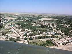
| View of the main town of Dehdadi from the air, from a helicopter of the Afghan Armed Forces ANA | |
Coordinates: 36 ° 40 ′ N , 67 ° 1 ′ E
Dehdadi is a district in the Afghan province of Balkh .
The district is named after the town of the same name, Dehdadi . The district of Dehadadi with around 254 km² is apart from the unofficial provincial capital Mazār-i Sharif , the smallest district in the province and one of the smallest districts in the north of Afghanistan.
The district has a north-south extension of about 25 km; from west to east it measures around 13 km.
geography
The district of Dehdadi, although of a small area, forms part of three major landscapes. The northern half of the area is still part of the Bactrian Plain , a 300 to 400 meter high plain. To the south, from the village of Dehdadi, there is a loess-covered, fertile foothills, which makes up about a third of the district. The southernmost and southeastern parts of the district are already part of the Afghan highlands. The district extends here up to a secondary peak of the 1752 m high Ali Kuh up to an altitude of 1530 meters. The lowest point of the district is in the far north, in the Bactrian plain at 337 meters above sea level.
military
Camp Shaheen is located south of the village of Dehdadi . The 209th Corps of the Afghan National Army is stationed here. Inside these barracks is Camp Mike Spann , a barracks of the RS troops (formerly ISAF), named after Mike Spann , the first US citizen to die in the context of the Afghanistan mission.
