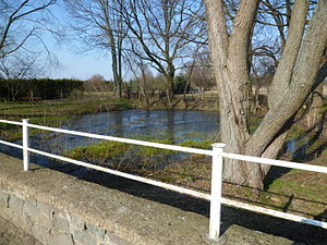
Mannhausen village pond
| Mannhausen village pond | ||
|---|---|---|

|
||
| Village pond in Mannhausen | ||
| Geographical location | Mannhausen , Calvörde municipality , Börde district , Saxony-Anhalt , Germany | |
| Data | ||
| Coordinates | 52 ° 25 '6.24 " N , 11 ° 13' 13.67" E | |
|
|
||
| surface | 0.035 ha | |
The village pond Mannhausen is a pond in the village of Mannhausen in the municipality of Calvörde in Saxony-Anhalt .
The village pond is on the right side of the street Zum Drömling towards Piplockenburg . Today it is almost completely enclosed by residential developments.
The pond is about 350 square meters. Its age is not documented; he has been storing the place's drinking water since ancient times. Until the 18th century it was located to the west and outside of the local area of Mannhausen. The economic upswing after the founding of the German Empire in 1871 resulted in population growth in the town and new buildings.
Today the water quality in the Mannhausen village pond is in poor condition. Water intake is risky for health reasons. It is not managed by any fishing association.
Mannhausen village pond within Calvörde |

