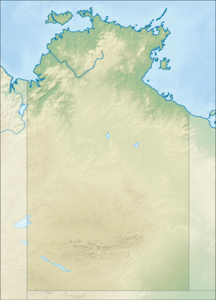
Driftwood Island
| Driftwood Island | ||
|---|---|---|
| Waters | Joseph Bonaparte Gulf , Indian Ocean | |
| Geographical location | 14 ° 55 ' S , 129 ° 36' E | |
|
|
||
| length | 6.7 km | |
| width | 1.2 km | |
| surface | 817,258 ha | |
| Residents | uninhabited | |
Driftwood Island is an uninhabited island in Australia's Northern Territory . It is 5.8 kilometers from mainland Australia. The island is located in the Joseph Bonaparte Gulf in the Darwin Coastal Bioregion .
The island is 6.7 kilometers long and 1.2 kilometers wide. It is administered by the Arnhem Land Aboriginal Land Trust . The neighboring islands are called Quoin Island and Clump Island .
The area has been part of the Victoria Daly Shire since July 1, 2008 , before that it was part of the large Unincorporated Northern Territory .
Individual evidence
- ↑ Introduced Species on Northern Territory Islands Australian Department of Environment and Energy. Last accessed on August 6, 2017
