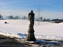
Drumlinfeld east of Kempten
The Drumlinfeld east of Kempten is a geotope in the natural area Iller-Vorberge. The extensive geotope can basically be located between the Kempter districts of Leubas and Leupolz .
Emergence
The drumlins near Kempten originated during the last ice age , the Würm glaciation in the Young Pleistocene , in the area of the ground moraine landscape of the Iller glacier . The drop-shaped to streamlined sediment bodies, elongated in a northerly direction, appear here in groups and staggered. They are usually several tens to several thousand meters long and up to 20 meters high. The streamlined bodies were formed beneath an actively moving glacier.
At the base of glaciers accumulated over a large area glacial till , the glacier under pressure from the ballast plastically reacted and could be transported in the direction of movement of the glacier. If the glacial till on older morphological elevations, e.g. B. meets moraines from older ice ages, the material is processed, pushed back and bulged. Drumlins are always aligned in the direction of the glacier movement and have a steep side facing the direction of movement and a flat side.
The Drumlinfeld east of Kempten was designated in 2007 by the Bavarian State Office for the Environment as a geoscientifically significant geotope (geotope no. 763R001), which is generally increasingly impaired by agricultural use and development.
See also
Individual evidence
- ↑ Walter Freudenberger and Klaus Schwerd: Explanations of the Geological Map of Bavaria 1: 500,000 ., 4th edition, Munich 1996, 329 pp.
- ↑ Geotope data sheet of the Bavarian State Office for the Environment: Geotope number 763R001 Drumlinfeld E von Kempten , accessed on July 24, 2014
literature
- Karl A. Habbe: On the origin of the drumlins of the South German Alpine Foreland (II): The sediments underneath. In: R. Aario and O. Heikkinen (Eds.): Proceedings of the third International Drumlin Symposium. Geomorphology, 1992.
Web links
- Geotope data sheet of the Bavarian State Office for the Environment: Geotope number 763R001 Drumlinfeld E von Kempten , accessed on July 24, 2014
Coordinates: 47 ° 44 ′ 42.7 " N , 10 ° 20 ′ 59.5" E

