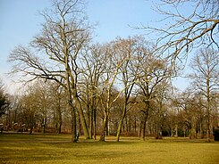
Ernst Grube Park
| Ernst Grube Park | |
|---|---|
| Park in Berlin | |

|
|
| Ernst Grube Park | |
| Basic data | |
| place | Berlin |
| District | Koepenick |
| Surrounding streets |
Ernst-Grube-Strasse (south and east) , Am Ernst-Grube-Park (north) |
| use | |
| User groups | Foot traffic ; leisure |
| Technical specifications | |
| Parking area | 1.6 hectares |
The Ernst-Grube-Park is an urban green area in the Berlin district of Köpenick in the Treptow-Köpenick district . It is named after the German politician and resistance fighter against the Nazi regime Ernst Grube .
Location and history
In the west, the park, which is located in Spindlersfeld , touches a larger meadow (the former Ernst-Grube-Stadion), which is demarcated from the Spindlersfelder Straße running here with a screen . The area has been a practice area for the Plänterwald dog sports club , which has its headquarters on Am Ernst-Grube-Park, since 2008 . To the east, the park is bordered by Ernst-Grube-Straße, which was called Spindlersfelder Straße until 1962. The park was also renamed in 1962 from Spindler's People's Park to Ernst-Grube-Park .
There is a communal playground at the southwest corner of the park . There is no precise delimitation of the park. Especially in the south it goes into the unfenced plots of town villas. Therefore, its area is about 140 m × 115 m.
The traffic plan in the Berlin address book from 1922 already contains a green area drawn in at the point where Spindler’s Volkspark is entered in the 1928 city map . The planned surrounding road and also a road crossing the site were still nameless in the traffic plan.
Individual evidence
- ↑ Homepage of HSV Plänterwald Berlin e. V. , accessed on March 2, 2014
- ↑ Berliner Zeitung , May 9, 1962, p. 8; State archive Berlin : HistoMapBerlin
- ↑ Playground with details of the equipment installed and an assessment of its condition; Year 2012 ; accessed on March 2, 2014
- ↑ expansion with the help of Google Earth detected
- ^ Cöpenick, road map . In: Berliner Adreßbuch , 1922, part 5, p. 1656 (north of Ahornallee, top left).
- ↑ Berlin State Archive : HistoMapBerlin
Coordinates: 52 ° 27 '3.7 " N , 13 ° 33" 42.2 " E