
Farahabad complex

The Farahabad complex consists of a group of monuments that have been preserved as the remains of the old town of Faraḥābād on the Caspian Sea in the northern Iranian province of Mazanderan . The complex was built during the reign of Abbas I built.
history
mosque
In the complex Faraḥābād, which was destroyed by the Cossack Stenka Razin in 1668 , there is now a settlement, the palace district, a mosque, a bath and a bridge over the Tajandrūd. The most important architectural monument is the brick Jameh Mosque. Despite its orientation towards Mecca, the main portal opens diagonally to the inner courtyard and is obviously adapted to an existing road network. The mosque has a total area of 62.50 m 2 . The inner courtyard of the mosque with a water basin in the middle measures 46.50 × 31 m. The south wing encloses the 16 m high, large central dome chamber that flanks the four-aisled hall. This mosque was built around the same time as the main courtyard mosque in Isfahan , the Shah Mosque (Masjed-e Šāh, Masjed-e Emām); it is smaller but has a similar floor plan.
bath
Bathing facilities can be seen both in the northeast, next to the mosque, and at the southwest end of the bridge; the one next to the mosque must have been completely destroyed and can hardly be identified today as Safavid Bath, while the one by the bridge dates from a later date.
bridges
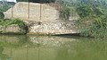
Two arches of the bridge are still preserved on the south bank of the Tajandrūd; six more supports lie under water on the river bed. All supports were placed on a dam base. The length of the bridge can no longer be determined, because the course of the river has shifted so that the line of the north bank has changed significantly. With its semicircular, upstream watercourses, the bridge is similar in construction and plan to the Safavid bridges from the 17th century. It was 6 m wide and carried the road across the river towards Qara Tepe and Shāh Kīla.
gallery

Jameh mosque

Farahabad Bridge

Jameh mosque

Jameh mosque

Jameh Mosque, panoramic picture


Jmeh mosque

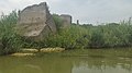
Remains of the Shah Abbasi Bridge on the Tajan River

Remains of the Shah Abbasi Bridge
The cornerstone of the Jahannama Palace in Tajan - Farah Abad Sari

Jahannama Palace seen from the river

.jpg)


Web links
Individual evidence
- ^ Encyclopaedia of the Iranian Architectural History . Cultural Heritage, Handicrafts and Tourism Organization of Iran. May 19, 2011. Archived from the original on August 1, 2019.
- ^ Farah Abad Historical Complex . In: en.tripyar.com . Retrieved August 1, 2019.
Coordinates: 36 ° 47 ′ 37.1 ″ N , 53 ° 6 ′ 57.3 ″ E