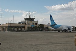
Herat airport
| Herat airport | |
|---|---|

|
|
| Characteristics | |
| ICAO code | EAR |
| IATA code | HEA |
| Coordinates | |
| Height above MSL | 977 m (3205 ft ) |
| Transport links | |
| Distance from the city center | 10.5 km south of Herat |
| Street | Herat-Farah Road |
| Basic data | |
| opening | 1950 |
| operator | US Air Force / ISAF |
| Passengers | Not specified |
| Air freight | Not specified |
| Start-and runway | |
| 18/36 | 2571 m × 46 m asphalt |
The Herat International Airport ( IATA : HEA , ICAO : OAHR , also called Herat Airfield ) is the regional airport of the city of Herat in Afghanistan . It is also used as a military airfield by the US Air Force and ISAF .
Location and transport links
Herat Airport is located on the A01 around ten kilometers southeast of the city of Herat.
Web links
- Herat (OAHR) , Ministry of Transport, Islamic Republic of Afghanistan (English)
- Airport data in the Aviation Safety Network (English)
- Information, photos and satellite images about Herat Airfield on globalsecurity.org (English)