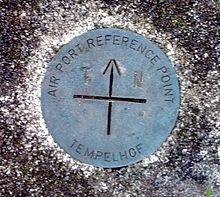
Aerodrome reference point


The airport reference point (engl. Aerodrome reference point , ARP ) is an air legally approved point on the grounds of an airfield that is significant for all position and altitude information on the grounds of the airport and its environment. Its coordinates are given in degrees of longitude and latitude as well as the height above sea level .
The airport reference point should be in the middle of the runway system. Since the construction protection area (§ 12 or § 17 LuftVG) depends on the airfield reference point, the old ARP is not very popular with subsequent changes to the runway system. If it has to be postponed, the rights of third parties are always affected due to the building protection area and thus there is a possibility of legal action. Since the airport reference point represents the center of the construction protection area, the height of the ARP must be chosen so that it reaches at least the lowest point of the runway system. In Frankfurt, for example, the ARP is a few meters below the rail system. This means that significantly more obstacles are detected in the vicinity of the airfield. The relevant national aviation authority determines the ARP with its level in cooperation with the German air traffic control .
- Example: Frankfurt Airport has the reference point 50 02, 00 N / 08 34, 23 E, i.e. 50 degrees, 2 minutes, 0 seconds north latitude and 8 degrees, 34 minutes and 23 seconds east longitude.
- Example: the now closed Tempelhof Airport in Berlin has the reference point 52 28, 25 N / 13 24, 06 E, i.e. 52 degrees, 28 minutes, 25 seconds north latitude and 13 degrees, 24 minutes and 6 seconds east longitude.
Individual evidence
- ^ Heinrich Mensen: Planning, installation and operation of airfields . 1st edition. Springer Verlag, Berlin 2007, ISBN 978-3-540-68106-9 , pp. 314 .