Fort San Andres
| Fort San Andres | ||
|---|---|---|
|
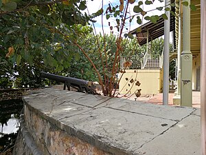
Remains of Fort San Andres |
||
| Creation time : | 18th century | |
| Place: | Port of Spain | |
| Geographical location | 10 ° 38 '52 " N , 61 ° 30' 38" W | |
|
|
||
The Fort San Andres is a former Fort in the Trinidadian capital Port of Spain , which houses a museum.
history
At the beginning of the 18th century, Trinidad was under Spanish rule. Capital was already Port of Spain, then Puerto de los Hispanioles that but to a ski jump from fascines disposal and earthwork no fortifications. This ski jump was about in the middle of today's Independence Square. From 1733 efforts were made to increase the defensive security Port of Spains, which provided for the construction of a fort called Fort San Andres. In the 1750s, under Governor Pedro de la Moneda, the San Andres Fort was built south of the old hill on a rock that was then still in the sea, connected to the mainland by a wooden dam. Under Governor José María Chacón , from 1784 the St. Ann's River, which at that time still flowed through the area of today's Woodford Square and past the defensive rampart, was diverted to its current bed, a construction process that lasted until 1787. In 1785 he had the then very rudimentary defense system moved to its current location and expanded there. After Trinidad was in 1797 without a fight like about the British, this 1803 built northwest of Port of Spain on a spur of the Range Northern , the Fort George , which was the primary base for the defense of Port of Spain by the lakeside. Fort San Andres then became irrelevant.
In the 19th century, a two-stage port expansion led to landfills, which resulted in Fort San Andres now being on the mainland. In the 20th century, the fort was no longer used for military purposes. It then served first as a harbor master's office and later as the location of the traffic police. In 1995 the building was renovated and brought up to the visual status of 1845; today it houses the "Museum of the City of Port of Spain".
construction
In the 1750s, Fort San Andres had a 4.5 meter high, crescent-shaped wall. It could be reached via a wooden drawbridge in the western part of the fort, which was connected to a 21 meter long, nine meter wide, also wooden dam to the mainland. At that time the fort had eleven cannons, which were aimed at the Gulf of Paria and arranged as batterie en barbette , a chain of cannons firing in parallel.
Today there is a two-story house built in the early 20th century on the site of the former fort, which houses the "Museum of the City of Port of Spain". Two cannons and a wall on the former lake side have been preserved from the time of military use.
reception
Since the fort has not been used for military purposes since the beginning of the 20th century, but a civilian building was erected on the site, the history of the area was largely unknown to the locals until the 1990s. It was only with the renovation of the traffic police building and its conversion into a museum in 1995 that the fort's history was made public to the residents of Port of Spains. As part of the restoration work, the foundation walls of the old fort were exposed inside the building. Fort San Andres is now referred to by the government as the "historic gateway to the city" and enjoys a corresponding status.
Web links
Individual evidence
- ^ A b Anthony, Michael : Historic Landmarks of Port of Spain, p. 5. Macmillan Caribbean, 2008.
- ↑ Bridget Brereton: A History of Modern Trinidad 1783--1962, p. 18. Terra Verde Resource Center, 2009
- ^ Mark Fraser: Gateway to our heritage . In: Trinidad Express . April 20, 2013.
- ↑ Bertuch, FJ, Allgemeine Geographische Ephemeriden, Volume 21, p. 408
- ↑ a b Newsday article from July 3, 2003, available online
- ↑ Guardian article, March 14, 2013, available online

