
Ganghwado
| Ganghwado | ||
|---|---|---|
| Waters | Yellow Sea | |
| Geographical location | 37 ° 42 ' N , 126 ° 26' E | |
|
||
| length | 27.2 km | |
| width | 15.7 km | |
| surface | 302.4 km² | |
| Highest elevation | Manisan 469 m |
|
| Residents | 65,500 217 inhabitants / km² |
|
| main place | Ganghwa-eup | |
 |
||

Ganghwado ( Kor. 강화도 , Hanja 江華 島 , rev. Ganghwado , MR Kanghwado ) is an island in the Yellow Sea off the west coast of South Korea . The island is located at the mouth of the Hangang and is separated from the mainland by the 400 to 1200 meter wide Yŏmha Canal , over which two bridges lead. Ganghwa's highest mountain is the Manisan , which is 469 m above sea level. It is the fifth largest island in South Korea.
Today around 65,500 people live on the island. It belongs administratively to the city of Incheon and forms the majority of the Ganghwa-gun district ( 강화군 , 江華 郡 ) belonging to Incheon . About half the population lives in Ganghwa-eup , a small town on the northeastern end of the island.
On the island are the dolmen sites, which were added to the UNESCO World Heritage List (Asia and Oceania) in 2000 as a World Heritage Site .
During Korea 's late Joseon Dynasty , the island was the site of several unsuccessful invasions by foreign powers. The high point of the attacks was the Ganghwa incident of 1875, in which Japanese troops tried unsuccessfully to conquer the island. As a result of the battle, the Japanese Navy blocked the sea area around the strategically important island. This ultimately led to the inevitable opening of the previously internationally isolated Korea.
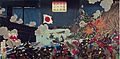
Color woodcut of the attack by Japanese troops on Ganghwado in 1875
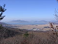
View from the Manisan
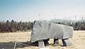
Dolmen on Ganghwado


