
Geoweg Mels


The Geoweg Mels is a historical circular hiking trail near the Castels hill in the municipality of Mels , canton of St. Gallen , Switzerland . It is part of the Sardona Geopark and was opened in 1996.
Routing
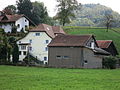
The Melser Geoweg leads around and on the hill of Castels, which was already inhabited and wooded in prehistoric times. It is signposted with wine-red signposts and begins on the edge of the village center of Mels at the bridge over the Seez river (point 497).
From there the path leads on the north side of the hill westwards along the Seez to the hamlet of Plons and on the south side of the hill on the military road through the Rossheld gorge (below Schlings). Before the hamlet of St. Martin turn left onto the plateau of the Castels hill for the hill path and back through the hamlet of St. Martin and down in front of the houses of Rüfi zur Seez and along this to the starting point at the bridge in Mels.
For the mountain hike on the 6 km long Melser Geoweg with 150 m difference in altitude, you need 3–4 hours, for a short tour with Mels Tourism 1 ½ hours.
subjects
The inconspicuous Castelserhügel was already settled in the New Stone Age, the Celts and Romans used it as a high fortress. During the Second World War , the artillery fortress Castels with a long corridor system was excavated in the Verrucano rock as part of the fortress Sargans .
Along the way, the following panels provide detailed information on the various topics of the geo path (panels in the order of the tour):
Section Seezufer towards Plons and return via Rossheld Gorge
- 22 stone carvings carpenter
- 23 Glashütte Mels (glass production)
- 1 overview
- 2 Mining at Castels
- 3 Plons iron smelter (smelting of ore from the Gonzen iron mine )
- 4 fortress construction Castels (fortress Kastels)

Mining
Iron smelter Plons: mansion

Military road Rossheld Gorge

Main entrance to the fortress of Castels


Section Hill Castels
- 5 Castels habitat
- 6 Settlement history of the Sarganserland (prehistory)
- 7 local naturalists
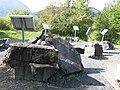
- 8 Millstone quarry (millstone extraction, millstone production)
- 9–17 Rock garden: geology, primary rocks, Verrucano, Triassic, Jura, Cretaceous, Tertiary, mountain construction in the * Sarganserland, valley fillings (at the highest point 643 m)
- 18 Verrucano or Melser sandstone

Roman walls and watchtowers, early medieval graves
Rock garden

Mill quarry


Section Seezufer towards Mels
- 19 Melser Mühlen (grain mills)
- 20 earth piers on the Nidberg
- 21 village fountain
St. Martin

Corn mill
former earth piers on the Nidberg

Mels village fountain with Verrucano plates


literature
- David Imper: Rocks, raw material extraction and stone processing in the Sarganserland . To the opening of the Geoweg. Self-published, Mels 1996
Web links
Individual evidence
Coordinates: 47 ° 2 '58.1 " N , 9 ° 24' 43.1" E ; CH1903: 749930 / two hundred twelve thousand eight hundred and twenty-three