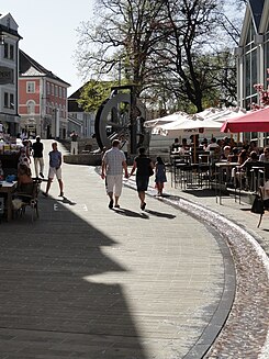
Gerberstrasse (Kempten)
| Gerberstrasse | |
|---|---|
| Street in Kempten (Allgäu) | |
| Gerberstrasse | |
| Basic data | |
| place | Kempten (Allgäu) |
| Hist. Names | Gerbergasse, Radbadgasse, Malzgasse, Hirschgasse, Kleine Steig |
| Connecting roads | Residenzplatz, Pfeilergraben, Illerstrasse |
| Cross streets | Heidengässele, In der Brandstatt, Kronenstrasse, Heinrichgasse |
| Places | Residenzplatz |
| use | |
| User groups | Pedestrians, cyclists, motorists |
| Technical specifications | |
| Street length | approx. 400 meters |
The Gerberstraße in Kempten (Allgäu) is part of a pedestrian and was one of the old main streets of the Imperial City. The “Mühlbachquartier” brand for Gerberstrasse, introduced in 2010, specifies a Mühlbach, but it was called Schlangenbach or Stadtbach. There is no evidence of a mill on Gerberstrasse.
location
As the main street of the imperial city and settlement zone for tanners , Gerberstraße initially consisted of Radbadgasse , which led from Radbadtor to Salzgasse (today Heinrichsgasse ). This was followed by Hirschgasse , probably named after the restaurant “Zum golden Hirsch”, which led up to the cross Kronenstrasse. This was followed by an area known as Gerber or Malzgasse . The latter name probably comes from the Zu den Sieben Hansen brewery located there. The last section led up to the monastery gate and was called Kleine Steig in reference to the narrowness of the alley at that time .
history
In the Middle Ages, today's street was heavily populated with guild houses: In addition to the weavers' guild with the largest number of members , the bakers, shoemakers and tailors also had their guild headquarters there.
With the demolition of the bulky houses in the Kleine Steig in 1892, a good transport connection was established between the imperial and the higher-lying abbey town.
From 1973, after Fischerstrasse, another pedestrian area was built on Gerberstrasse. During this time, a hoarding department store with the characteristic hydrangea tiles was built to compete with the residence .
At the end of 2010, after a six-month renovation phase, Gerberstrasse was reopened. During the renovation work, a four-meter high “mill wheel” with an exposed watercourse - also known as the “piss channel” by the population - up to Kronenstrasse was created. An old well, reminiscent of the water shortage in the early 1970s, was dismantled with the associated seating steps and replaced with a new one. The cost of the renovation work amounted to 1.2 million euros.
Development
The street parallel to Rathausplatz and running to Residenzplatz was originally built with houses on a Gothic basis; they were renewed in the 17th and 18th centuries. In 1741, various houses across the street were destroyed by fire up to the confluence of the Heidengässel. In Gerberstrasse, the old buildings - if they still exist - are disturbed by shop fixtures and shop windows.
Modern buildings of the 20th century were created during the so-called old town renovation , a nationwide urban planning pilot project that began in 1959. Kempten served here as a model. Listed buildings are often demolished without being checked, and some are rebuilt using modern construction methods.
Individual evidence
- ↑ a b c Christian Ilg: From Kempten's past days. City stories: the streets and houses of the municipality of Kempten. Volume IV, self-published, Kempten 2004, p. 70ff.
- ^ Alexander Duke of Württemberg: City of Kempten (= Bavarian State Office for Monument Preservation [Hrsg.]: Monuments in Bavaria . Volume VII.85 ). Schnell & Steiner publishing house, Munich / Zurich 1990, ISBN 3-7954-1003-7 , p. XXXIV .
- ^ City of Kempten (ed.): Kempten im Allgäu. (3rd documentation), Kösel, Kempten 1972, p. 47f.
- ↑ Christine Tröger: "Jewel in the inner city" In: Kreisbote.de, November 30, 2010. (accessed on May 14, 2013)
Web links
Coordinates: 47 ° 43 ′ 39.4 " N , 10 ° 18 ′ 54.4" E

