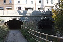
Geyer Bridge
The Geyerbrücke is a bridge in Munich .
location
The Geyerbrücke is located in the Isarvorstadt along the Kapuzinerstraße, which runs along the southern edge of the Altes Südfriedhof . It leads over the Westermühlbach , which flows north along the east side of the cemetery.
history
A wooden bridge over the Westermühlbach and the Pesenbach was built in 1856/57 at the site of the current bridge , into which the Große Stadtbach was divided a few 100 m further south and which were still close to each other here. When the Wittelsbacherbrücke was built in 1874 , it was clear that the old wooden bridge would not be able to cope with the increasing traffic. Therefore it was replaced by a stone arch bridge, which was widened again in 1904. At the beginning of the 20th century the streams were completely vaulted. The vaults have been open again since 2008.
description
The Geyer Bridge is an arch bridge. It has a length of 21.26 m and a width of 22.63 m. The two arches have spans of 9.76 m and 10.00 m.
A footpath and cycle path runs under one arch, the Westermühlbach flows under the other. The Pesenbach has now been drained. The two arches not only lead under the street, but also under the house on the north side of the street.
literature
- Christine Rädlinger : History of the Munich bridges . Ed .: City of Munich, Construction Department. Verlag Franz Schiermeier, Munich 2008, ISBN 978-3-9811425-2-5 .
Web links
Coordinates: 48 ° 7 '27.2 " N , 11 ° 33' 51.7" E

