
Grubser Tobel
Coordinates: 47 ° 9 ′ 0 ″ N , 9 ° 52 ′ 0 ″ E

The Grubser Tobel is a small mountain valley on the southern slope of the Lechquellengebirge in Vorarlberg in the municipality of Bludenz . It consists of two branches, the outer one (to the west of the Stierkopf, which rises prominently and ruggedly above the Klostertal, 1801 m above sea level ), and the inner Grubser Tobel (east of the Stierkopf).
topography
It is located east of the Rungelin forest in the Grubs / Radin plot above the Klostertal and is traversed by a small mountain river.
The initially wide, mainly willow-covered valley begins at about 625 meters at the mouth of the stream in the Alfenz and stretches, becoming ever narrower and more rugged, to over 1500 meters above the highest point (1579 m) of the Katzenköpf , the Elsspitze (1980 m) and the Stierkopf (1801 m).
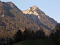
The bull's head in the evening sun, in front of it the Outer Grubser Tobel, which is already in the shade. Top left is the highest point (1579 m) of the cats' heads.
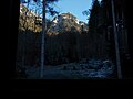
The rugged end of the valley of the Grubser Tobel with the bull's head in the middle (view from the Hellwaldhütte)

Outer Grubser Tobel to the left of the spruce, above the Elsspitze (1980 m), right behind it the snow-covered Breithorn (Gaisberg, 2009 m). On the right the inside Grubser Tobel with the bull's head above it.

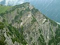
View from the ascent to Gams Freiheit: the pastures of the Elsalpe, which rise from the north, plunge steeply into the inner Grubser Tobel to the south. The bull's head above the precipice.

View from almost 1900 m into the abyss of the Outer Grubser Tobel.
Bull's head (1801 m) from a Zacken (1888 m, near the Elsfürkele), right below Alfenzwerk -Radin reservoir.


Individual evidence
- ↑ New access road to Grubs (July 10, 2011)
- ↑ Vorarlberg Atlas4. Retrieved March 21, 2020 .